
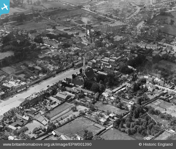
epw001390 ENGLAND (1920). The Market Place and town centre, Romford, 1920
© Copyright OpenStreetMap contributors and licensed by the OpenStreetMap Foundation. 2024. Cartography is licensed as CC BY-SA.
Nearby Images (5)
EPW001390

EPW001391

EPW006268

EPW001394

EPW001405

Details
| Title | [EPW001390] The Market Place and town centre, Romford, 1920 |
| Reference | EPW001390 |
| Date | 7-June-1920 |
| Link | |
| Place name | ROMFORD |
| Parish | |
| District | |
| Country | ENGLAND |
| Easting / Northing | 551194, 188956 |
| Longitude / Latitude | 0.18227661151396, 51.578685291788 |
| National Grid Reference | TQ512890 |
Pins
 Paul Winslow |
Monday 23rd of May 2022 09:05:53 PM | |
Paul Winslow |
Monday 23rd of May 2022 09:02:22 PM | |
 Class31 |
Tuesday 30th of October 2012 08:31:55 AM | |
BigglesH |
Thursday 12th of July 2012 02:38:33 AM | |
Colin |
Wednesday 27th of June 2012 10:56:58 AM | |
TonyF |
Wednesday 27th of June 2012 08:32:59 AM | |
TonyF |
Wednesday 27th of June 2012 08:30:28 AM | |
I think you are right - wasn`t it next door to the main Post Office? Somewhere in the vicinity was a small street - forgotten the name it maybe Exchange Street or Havana Close now? Halfway down on the left hand side was a doorway and a flight of steps which led up to The Luciana Billiards and Snooker Club. Strictly teetotal - tea and lemonade. We used to leave and then try to get served a pint of Mild & Bitter at The Rising Sun Pub - opposite the railway station entrance. Is the pub still there - does anyone know? |
Roy |
Thursday 28th of June 2012 06:26:29 PM |
It was a few doors along from the Post Office. Exchange Street was further down, same side, towards the Golden Lion traffic lights - it's still there. The snooker hall is still there, it was the centre of Barry Hearm's empire for a while and where Steve Davis used to play I think. Havana Close was further up, same side of the road, the Odean stood on the corned and it lead down to the back entrance to the Brewery. I loved it there in the 1960s because as a young police cadet I could volunteer to cover all the pop concerts so saw the Beatles and Rolling Stones plus a lot of other bands when they were on tour - and it was a great place to meet girls !!! I've just remembered, the toy shop in the arcade there was called 'Craddocks', not sure where I dragged that up from. The raods are all still there though Romford has changed beyond recognition, the roads hardly look the same. And there was the ABC cinema, after the railway station past the coal yards. The Rising Sun is still there although it has changed beyond recognition. Only the really brave venture out into Romford pubs according to my family who still live in the area. |
TonyF |
Thursday 28th of June 2012 11:53:04 PM |
And there was also the Como coffee bar under the railway bridge, just along from the pub !!! |
TonyF |
Thursday 28th of June 2012 11:54:35 PM |
Tony - thanks for the reminder about the ABC cinema being along the road to the Odeon! I can remember queuing at one and if we didn't get in, going along to the other one (of coure you had to get the timing right). I can also remember the Odeon having the 'upper circle'. (I am a bit younger than you - being born in 1960 0 so missed the bands playing there!) I played snooker with my Dad at the hall that Steve Davis was practising at in the mid-late 70's. Does anyone remember the little paper shop under the railway arch? I loved the lemon ice they did - and my real favourite was a half&half' (vanilla & the lemon ice) |
Leylie |
Sunday 22nd of July 2012 12:46:07 PM |
hi the building you say was the police station was the crown office (main post office) in south st the police where a little further down, I was a telegram boy there from 1958/61 and our bikes and office was down the side of the church there round the back. we used to visit the snooker hall often in our breaks and after work.also como.s and another coffee bar by the odean. I also met the rolling stones walking back to the odean for thier 2nd performance had a long chat with the nice guys |
trampers |
Monday 2nd of September 2013 05:04:01 PM |
I remember the coffee bar almost opposite the Odeon, it was called Sherrys, a long narrow place with stools along a counter. |
RomfordLad |
Sunday 23rd of November 2014 05:16:00 AM |
TonyF |
Wednesday 27th of June 2012 08:26:57 AM | |
TonyF |
Wednesday 27th of June 2012 08:23:02 AM | |
This is not the site of Oldchurch Hospital. The Hospital was situated south of the railway. It was rebuilt about half a mile further south to Oldchurch park and renamed the Queen Elizabeth Hospital. |
Davel |
Sunday 11th of May 2014 09:20:08 AM |
TonyF |
Wednesday 27th of June 2012 08:20:18 AM | |
This is Waterloo Road not Oldchurch Road, which is south of the railway lines, |
Paul Winslow |
Monday 23rd of May 2022 09:14:58 PM |
TonyF |
Wednesday 27th of June 2012 08:18:58 AM | |
TonyF |
Wednesday 27th of June 2012 08:16:10 AM | |
TonyF |
Tuesday 26th of June 2012 07:05:03 AM | |
TonyF |
Tuesday 26th of June 2012 07:04:08 AM | |
chris1209 |
Monday 25th of June 2012 07:13:04 PM |
User Comment Contributions
This photo was taken from North East of the Market Place. The road running through the Market was the original A12, probably before those numbers were allocated. The modern A12 is out of picture, to the right and behind the camera. |
BigglesH |
Thursday 12th of July 2012 02:44:53 AM |


