
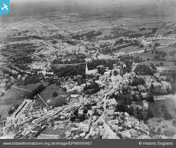
epw000467 ENGLAND (1920). Harrow on the Hill, from the south-west, 1920
© Copyright OpenStreetMap contributors and licensed by the OpenStreetMap Foundation. 2024. Cartography is licensed as CC BY-SA.
Nearby Images (27)
EPW000467

EAW024232

EPW000462

EPW025547

EAW042768

EPW000469

EPW000463

EPW000461

EPW053680

EAW042771

EAW014888

EPW053679

EAW042772

EPW005357

EPW006295

EAW042770

EPW018764

EAW014885

EPW000468

EPW005356

EPW006290

EAW042767

EAW042769

EPW000466

EAW014887

EPW000470

EAW024233

Details
| Title | [EPW000467] Harrow on the Hill, from the south-west, 1920 |
| Reference | EPW000467 |
| Date | April-1920 |
| Link | |
| Place name | HARROW ON THE HILL |
| Parish | |
| District | |
| Country | ENGLAND |
| Easting / Northing | 515251, 187297 |
| Longitude / Latitude | -0.33678339687183, 51.572271196299 |
| National Grid Reference | TQ153873 |
Pins
 Sweet Pete |
Friday 6th of November 2015 04:29:34 PM | |
Mistaron |
Thursday 5th of March 2015 12:25:16 AM | |
kels |
Tuesday 1st of April 2014 03:54:57 PM | |
JamesMac |
Wednesday 28th of August 2013 10:22:13 PM | |
JamesMac |
Wednesday 28th of August 2013 10:12:04 PM | |
JamesMac |
Wednesday 28th of August 2013 10:07:03 PM | |
JamesMac |
Wednesday 28th of August 2013 10:00:49 PM | |
JamesMac |
Wednesday 28th of August 2013 09:55:34 PM | |
JamesMac |
Wednesday 28th of August 2013 09:54:32 PM | |
JamesMac |
Wednesday 28th of August 2013 09:53:24 PM | |
JamesMac |
Wednesday 28th of August 2013 09:50:50 PM | |
JamesMac |
Wednesday 28th of August 2013 09:49:15 PM | |
JamesMac |
Wednesday 28th of August 2013 09:47:36 PM | |
JamesMac |
Wednesday 28th of August 2013 09:46:52 PM | |
JamesMac |
Wednesday 28th of August 2013 09:42:32 PM | |
I think that this section of Kenton Road was originally called Tyburn Lane and continued to the junction with Kenton Lane, where it continued as Kenton Lane to The Hyde. The name Kenton Road appeared when the Kenton area was developed in the 1920s and the road was improved and realigned in parts. A very short section of Tyburn Lane still survives in that name between Grove Hill Road and Peterborough Road. |
The Laird |
Tuesday 10th of January 2017 09:59:28 PM |
JamesMac |
Wednesday 28th of August 2013 09:38:01 PM | |
Catchpole |
Tuesday 24th of July 2012 09:14:39 AM | |
Catchpole |
Tuesday 24th of July 2012 09:12:40 AM | |
Catchpole |
Thursday 12th of July 2012 05:10:16 PM | |
Catchpole |
Thursday 12th of July 2012 05:09:13 PM | |
Catchpole |
Thursday 12th of July 2012 05:08:14 PM | |
Michael Sullivan |
Thursday 5th of July 2012 10:35:44 PM | |
Michael Sullivan |
Thursday 5th of July 2012 10:34:51 PM | |
Michael Sullivan |
Thursday 5th of July 2012 10:33:44 PM | |
Michael Sullivan |
Thursday 5th of July 2012 10:32:56 PM | |
Michael Sullivan |
Thursday 5th of July 2012 10:23:50 PM | |
Michael Sullivan |
Thursday 5th of July 2012 10:23:05 PM | |
Michael Sullivan |
Thursday 5th of July 2012 10:21:35 PM | |
This is Trafalgar Terrace |
Catchpole |
Wednesday 11th of July 2012 09:19:36 AM |
Michael Sullivan |
Thursday 5th of July 2012 10:20:55 PM | |
Michael Sullivan |
Thursday 5th of July 2012 10:20:10 PM | |
Michael Sullivan |
Thursday 5th of July 2012 10:19:15 PM | |
Michael Sullivan |
Thursday 5th of July 2012 10:18:10 PM |


