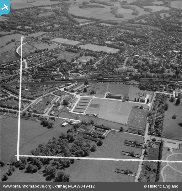
eaw049412 ENGLAND (1953). The British Coal Utilisation Research Association (BCURA) on Randalls Road and environs, Leatherhead, 1953. This image was marked by Aerofilms Ltd for photo editing.
© Copyright OpenStreetMap contributors and licensed by the OpenStreetMap Foundation. 2024. Cartography is licensed as CC BY-SA.
Nearby Images (12)
Details
| Title | [EAW049412] The British Coal Utilisation Research Association (BCURA) on Randalls Road and environs, Leatherhead, 1953. This image was marked by Aerofilms Ltd for photo editing. |
| Reference | EAW049412 |
| Date | 19-May-1953 |
| Link | |
| Place name | LEATHERHEAD |
| Parish | |
| District | |
| Country | ENGLAND |
| Easting / Northing | 516201, 157082 |
| Longitude / Latitude | -0.33299796886232, 51.300480388051 |
| National Grid Reference | TQ162571 |


![[EAW049412] The British Coal Utilisation Research Association (BCURA) on Randalls Road and environs, Leatherhead, 1953. This image was marked by Aerofilms Ltd for photo editing.](http://britainfromabove.org.uk/sites/all/libraries/aerofilms-images/public/100x100/EAW/049/EAW049412.jpg)
![[EAW049413] The British Coal Utilisation Research Association (BCURA) on Randalls Road and environs, Leatherhead, 1953. This image was marked by Aerofilms Ltd for photo editing.](http://britainfromabove.org.uk/sites/all/libraries/aerofilms-images/public/100x100/EAW/049/EAW049413.jpg)
![[EAW049411] The British Coal Utilisation Research Association (BCURA) on Randalls Road and environs, Leatherhead, 1953. This image was marked by Aerofilms Ltd for photo editing.](http://britainfromabove.org.uk/sites/all/libraries/aerofilms-images/public/100x100/EAW/049/EAW049411.jpg)
![[EAW049418] The British Coal Utilisation Research Association (BCURA) on Randalls Road and environs, Leatherhead, 1953. This image was marked by Aerofilms Ltd for photo editing.](http://britainfromabove.org.uk/sites/all/libraries/aerofilms-images/public/100x100/EAW/049/EAW049418.jpg)
![[EAW049415] The British Coal Utilisation Research Association (BCURA) on Randalls Road and environs, Leatherhead, 1953. This image was marked by Aerofilms Ltd for photo editing.](http://britainfromabove.org.uk/sites/all/libraries/aerofilms-images/public/100x100/EAW/049/EAW049415.jpg)
![[EAW049414] The British Coal Utilisation Research Association (BCURA) on Randalls Road and environs, Leatherhead, 1953. This image was marked by Aerofilms Ltd for photo editing.](http://britainfromabove.org.uk/sites/all/libraries/aerofilms-images/public/100x100/EAW/049/EAW049414.jpg)
![[EAW024014] The General Cable Manufacturing Co Works, Leatherhead, 1949. This image has been produced from a print marked by Aerofilms Ltd for photo editing.](http://britainfromabove.org.uk/sites/all/libraries/aerofilms-images/public/100x100/EAW/024/EAW024014.jpg)
![[EAW024017] The General Cable Manufacturing Co Works, Leatherhead, 1949. This image was marked by Aerofilms Ltd for photo editing.](http://britainfromabove.org.uk/sites/all/libraries/aerofilms-images/public/100x100/EAW/024/EAW024017.jpg)
![[EAW024013] The General Cable Manufacturing Co Works, Leatherhead, 1949. This image has been produced from a print marked by Aerofilms Ltd for photo editing.](http://britainfromabove.org.uk/sites/all/libraries/aerofilms-images/public/100x100/EAW/024/EAW024013.jpg)
![[EAW024016] The General Cable Manufacturing Co Works, Leatherhead, 1949. This image has been produced from a print marked by Aerofilms Ltd for photo editing.](http://britainfromabove.org.uk/sites/all/libraries/aerofilms-images/public/100x100/EAW/024/EAW024016.jpg)
![[EAW024012] The General Cable Manufacturing Co Works, Leatherhead, 1949. This image has been produced from a print marked by Aerofilms Ltd for photo editing.](http://britainfromabove.org.uk/sites/all/libraries/aerofilms-images/public/100x100/EAW/024/EAW024012.jpg)
![[EPW057009] The Kingston Road and environs, Leatherhead, 1938](http://britainfromabove.org.uk/sites/all/libraries/aerofilms-images/public/100x100/EPW/057/EPW057009.jpg)


