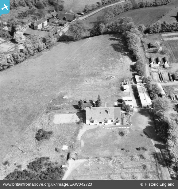
eaw042723 ENGLAND (1952). Fulvenden Farm (Home Farm) and Fulvens Farm, Hoe, 1952
© Copyright OpenStreetMap contributors and licensed by the OpenStreetMap Foundation. 2024. Cartography is licensed as CC BY-SA.
Nearby Images (16)
Details
| Title | [EAW042723] Fulvenden Farm (Home Farm) and Fulvens Farm, Hoe, 1952 |
| Reference | EAW042723 |
| Date | 29-April-1952 |
| Link | |
| Place name | HOE |
| Parish | SHERE |
| District | |
| Country | ENGLAND |
| Easting / Northing | 509591, 146388 |
| Longitude / Latitude | -0.43106058744256, 51.205657830386 |
| National Grid Reference | TQ096464 |
Pins
Be the first to add a comment to this image!


![[EAW042723] Fulvenden Farm (Home Farm) and Fulvens Farm, Hoe, 1952](http://britainfromabove.org.uk/sites/all/libraries/aerofilms-images/public/100x100/EAW/042/EAW042723.jpg)
![[EAW042721] Fulvenden Farm (Home Farm), Hoe, 1952](http://britainfromabove.org.uk/sites/all/libraries/aerofilms-images/public/100x100/EAW/042/EAW042721.jpg)
![[EAW042720] Fulvenden Farm (Home Farm), Hoe, 1952](http://britainfromabove.org.uk/sites/all/libraries/aerofilms-images/public/100x100/EAW/042/EAW042720.jpg)
![[EAW042724] Fulvenden Farm (Home Farm), Hoe, 1952](http://britainfromabove.org.uk/sites/all/libraries/aerofilms-images/public/100x100/EAW/042/EAW042724.jpg)
![[EAW042722] Fulvenden Farm (Home Farm), Hoe, 1952](http://britainfromabove.org.uk/sites/all/libraries/aerofilms-images/public/100x100/EAW/042/EAW042722.jpg)
![[EAW042725] Fulvenden Farm (Home Farm), Hoe, 1952](http://britainfromabove.org.uk/sites/all/libraries/aerofilms-images/public/100x100/EAW/042/EAW042725.jpg)
![[EAW042728] Fulvenden Farm (Home Farm) and the surrounding area, Hoe, 1952](http://britainfromabove.org.uk/sites/all/libraries/aerofilms-images/public/100x100/EAW/042/EAW042728.jpg)
![[EAW042730] Fulvenden Farm (Home Farm) and the surrounding area, Hoe, 1952](http://britainfromabove.org.uk/sites/all/libraries/aerofilms-images/public/100x100/EAW/042/EAW042730.jpg)
![[EAW042727] Fulvenden Farm (Home Farm) hay barns and Rad Lodge, Hoe, 1952](http://britainfromabove.org.uk/sites/all/libraries/aerofilms-images/public/100x100/EAW/042/EAW042727.jpg)
![[EAW042726] Fulvenden Farm (Home Farm) hay barns and Rad Lodge, Hoe, 1952](http://britainfromabove.org.uk/sites/all/libraries/aerofilms-images/public/100x100/EAW/042/EAW042726.jpg)
![[EAW042729] Fulvenden Farm (Home Farm) and the surrounding area, Hoe, 1952](http://britainfromabove.org.uk/sites/all/libraries/aerofilms-images/public/100x100/EAW/042/EAW042729.jpg)
![[EAW042718] Fulvens Farm, Hoe, 1952](http://britainfromabove.org.uk/sites/all/libraries/aerofilms-images/public/100x100/EAW/042/EAW042718.jpg)
![[EAW042719] Fulvens Farm, Hoe, 1952. This image was marked by Aerofilms Ltd for photo editing.](http://britainfromabove.org.uk/sites/all/libraries/aerofilms-images/public/100x100/EAW/042/EAW042719.jpg)
![[EAW042717] Fulvens Farm, Hoe, 1952](http://britainfromabove.org.uk/sites/all/libraries/aerofilms-images/public/100x100/EAW/042/EAW042717.jpg)
![[EAW042732] Fulvenden Farm (Home Farm) and the surrounding area, Hoe, 1952](http://britainfromabove.org.uk/sites/all/libraries/aerofilms-images/public/100x100/EAW/042/EAW042732.jpg)
![[EAW042731] Fulvenden Farm (Home Farm) and the surrounding area, Hoe, 1952](http://britainfromabove.org.uk/sites/all/libraries/aerofilms-images/public/100x100/EAW/042/EAW042731.jpg)


