
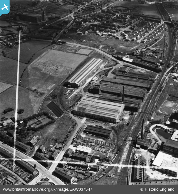
eaw037547 ENGLAND (1951). The Daniel Adamson & Co Ltd Engineering Works, Dukinfield, 1951. This image has been produced from a print marked by Aerofilms Ltd for photo editing.
© Copyright OpenStreetMap contributors and licensed by the OpenStreetMap Foundation. 2024. Cartography is licensed as CC BY-SA.
Nearby Images (38)
EAW037547

EAW037550

EAW037549

EAW037545

EAW052649

EAW052647

EAW026616

EAW008501

EAW026615

EAW037546

EAW037544

EAW026614
, Dukinfield, 1949. This image has been produced from a damaged negative.")
EAW026611

EAW052646

EAW008502

EAW026618

EAW008498

EAW037551

EAW026619

EAW037548

EAW037553

EAW026617

EAW037552

EAW052648

EAW008499

EAW026620

EAW026621

EAW008500

EAW037554

EAW026613
, Dukinfield, 1949. This image has been produced from a damaged negative.")
EAW008497

EAW008495

EAW026612

EAW008494

EAW008496

EAW052651

EAW052650

EAW037555

Details
| Title | [EAW037547] The Daniel Adamson & Co Ltd Engineering Works, Dukinfield, 1951. This image has been produced from a print marked by Aerofilms Ltd for photo editing. |
| Reference | EAW037547 |
| Date | 1-July-1951 |
| Link | |
| Place name | DUKINFIELD |
| Parish | |
| District | |
| Country | ENGLAND |
| Easting / Northing | 394484, 396672 |
| Longitude / Latitude | -2.0830993564314, 53.466506059222 |
| National Grid Reference | SJ945967 |
Pins
Be the first to add a comment to this image!


