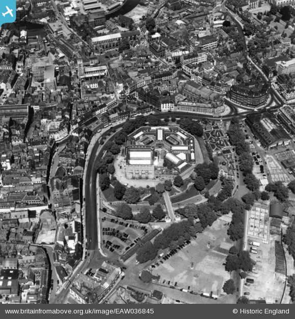
eaw036845 ENGLAND (1951). The Castle and environs, Norwich, 1951. This image has been produced from a print.
© Copyright OpenStreetMap contributors and licensed by the OpenStreetMap Foundation. 2024. Cartography is licensed as CC BY-SA.
Nearby Images (26)
Details
| Title | [EAW036845] The Castle and environs, Norwich, 1951. This image has been produced from a print. |
| Reference | EAW036845 |
| Date | 5-June-1951 |
| Link | |
| Place name | NORWICH |
| Parish | |
| District | |
| Country | ENGLAND |
| Easting / Northing | 623169, 308512 |
| Longitude / Latitude | 1.2979337783739, 52.628053506477 |
| National Grid Reference | TG232085 |
Pins
Be the first to add a comment to this image!


![[EAW036845] The Castle and environs, Norwich, 1951. This image has been produced from a print.](http://britainfromabove.org.uk/sites/all/libraries/aerofilms-images/public/100x100/EAW/036/EAW036845.jpg)
![[EAW008140] Norwich Castle and environs, Norwich, 1947. This image has been produced from a print.](http://britainfromabove.org.uk/sites/all/libraries/aerofilms-images/public/100x100/EAW/008/EAW008140.jpg)
![[EAW024400] Norwich Castle and the city centre, Norwich, 1949](http://britainfromabove.org.uk/sites/all/libraries/aerofilms-images/public/100x100/EAW/024/EAW024400.jpg)
![[EAW008138] Norwich Castle, Norwich, 1947. This image has been produced from a print.](http://britainfromabove.org.uk/sites/all/libraries/aerofilms-images/public/100x100/EAW/008/EAW008138.jpg)
![[EAW037289] The Castle, Norwich, 1951. This image has been produced from a print.](http://britainfromabove.org.uk/sites/all/libraries/aerofilms-images/public/100x100/EAW/037/EAW037289.jpg)
![[EAW008137] Norwich Castle, Norwich, 1947. This image has been produced from a print.](http://britainfromabove.org.uk/sites/all/libraries/aerofilms-images/public/100x100/EAW/008/EAW008137.jpg)
![[EAW008142] Norwich Castle, Norwich, 1947](http://britainfromabove.org.uk/sites/all/libraries/aerofilms-images/public/100x100/EAW/008/EAW008142.jpg)
![[EAW002886] Norwich Castle Museum, Norwich, 1946](http://britainfromabove.org.uk/sites/all/libraries/aerofilms-images/public/100x100/EAW/002/EAW002886.jpg)
![[EAW008139] Norwich Castle, Norwich, 1947. This image has been produced from a print.](http://britainfromabove.org.uk/sites/all/libraries/aerofilms-images/public/100x100/EAW/008/EAW008139.jpg)
![[EAW008141] Norwich Castle and environs, Norwich, 1947. This image was marked by Aerofilms Ltd for photo editing.](http://britainfromabove.org.uk/sites/all/libraries/aerofilms-images/public/100x100/EAW/008/EAW008141.jpg)
![[EAW024399] Norwich Castle and environs, Norwich, from the west, 1949](http://britainfromabove.org.uk/sites/all/libraries/aerofilms-images/public/100x100/EAW/024/EAW024399.jpg)
![[EPW001766] Norwich Castle and Cattle market, Norwich, 1920](http://britainfromabove.org.uk/sites/all/libraries/aerofilms-images/public/100x100/EPW/001/EPW001766.jpg)
![[EPW021203] The Castle and town centre, Norwich, 1928](http://britainfromabove.org.uk/sites/all/libraries/aerofilms-images/public/100x100/EPW/021/EPW021203.jpg)
![[EAW002893] Norwich Castle Museum, Norwich Cathedral and the city centre, Norwich, 1946](http://britainfromabove.org.uk/sites/all/libraries/aerofilms-images/public/100x100/EAW/002/EAW002893.jpg)
![[EAW008200] The cattle market and environs, Norwich, 1947](http://britainfromabove.org.uk/sites/all/libraries/aerofilms-images/public/100x100/EAW/008/EAW008200.jpg)
![[EAW037291] The Castle, City Hall and city centre, Norwich, 1951. This image has been produced from a print.](http://britainfromabove.org.uk/sites/all/libraries/aerofilms-images/public/100x100/EAW/037/EAW037291.jpg)
![[EAW036848] The city centre, Norwich, 1951. This image has been produced from a print.](http://britainfromabove.org.uk/sites/all/libraries/aerofilms-images/public/100x100/EAW/036/EAW036848.jpg)
![[EAW002895] Norwich Castle Museum, the City Hall and the city centre, Norwich, 1946](http://britainfromabove.org.uk/sites/all/libraries/aerofilms-images/public/100x100/EAW/002/EAW002895.jpg)
![[EAW036846] The city centre, Norwich, 1951. This image has been produced from a print.](http://britainfromabove.org.uk/sites/all/libraries/aerofilms-images/public/100x100/EAW/036/EAW036846.jpg)
![[EPW021212] The Market Place and Castle, Norwich, 1928](http://britainfromabove.org.uk/sites/all/libraries/aerofilms-images/public/100x100/EPW/021/EPW021212.jpg)
![[EPW001970A] General view of the town centre, Norwich, from the west, 1920](http://britainfromabove.org.uk/sites/all/libraries/aerofilms-images/public/100x100/EPW/001/EPW001970A.jpg)
![[EAW037292] Gentleman's Walk and the city centre, Norwich, 1951. This image has been produced from a print.](http://britainfromabove.org.uk/sites/all/libraries/aerofilms-images/public/100x100/EAW/037/EAW037292.jpg)
![[EAW037290] The Castle, Market Place and City Hall, Norwich, 1951. This image has been produced from a print.](http://britainfromabove.org.uk/sites/all/libraries/aerofilms-images/public/100x100/EAW/037/EAW037290.jpg)
![[EAW001994] The Norwich Union offices on Surrey Street, Norwich, from the north, 1946](http://britainfromabove.org.uk/sites/all/libraries/aerofilms-images/public/100x100/EAW/001/EAW001994.jpg)
![[EAW001953] Bally and Haldinstein Ltd Boot and Shoe Manufactory, Norwich, 1946](http://britainfromabove.org.uk/sites/all/libraries/aerofilms-images/public/100x100/EAW/001/EAW001953.jpg)
![[EPW001970] General view of the town centre, Norwich, from the south-west, 1920](http://britainfromabove.org.uk/sites/all/libraries/aerofilms-images/public/100x100/EPW/001/EPW001970.jpg)


