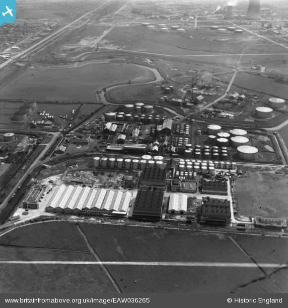
eaw036265 ENGLAND (1951). Part of the Oil Refinery at Stanlow, Ellesmere Port, 1951. This image has been produced from a print marked by Aerofilms Ltd for photo editing.
© Copyright OpenStreetMap contributors and licensed by the OpenStreetMap Foundation. 2024. Cartography is licensed as CC BY-SA.
Nearby Images (30)
Details
| Title | [EAW036265] Part of the Oil Refinery at Stanlow, Ellesmere Port, 1951. This image has been produced from a print marked by Aerofilms Ltd for photo editing. |
| Reference | EAW036265 |
| Date | 12-May-1951 |
| Link | |
| Place name | ELLESMERE PORT |
| Parish | |
| District | |
| Country | ENGLAND |
| Easting / Northing | 342364, 375838 |
| Longitude / Latitude | -2.8644408931324, 53.276111527091 |
| National Grid Reference | SJ424758 |
Pins
Be the first to add a comment to this image!


![[EAW036265] Part of the Oil Refinery at Stanlow, Ellesmere Port, 1951. This image has been produced from a print marked by Aerofilms Ltd for photo editing.](http://britainfromabove.org.uk/sites/all/libraries/aerofilms-images/public/100x100/EAW/036/EAW036265.jpg)
![[EPW046266] Lobitos Oil Refinery, Ellesmere Port, 1934](http://britainfromabove.org.uk/sites/all/libraries/aerofilms-images/public/100x100/EPW/046/EPW046266.jpg)
![[EPW046264] Lobitos Oil Refinery, Ellesmere Port, 1934](http://britainfromabove.org.uk/sites/all/libraries/aerofilms-images/public/100x100/EPW/046/EPW046264.jpg)
![[EPW046272] Lobitos Oil Refinery and environs, Ellesmere Port, 1934](http://britainfromabove.org.uk/sites/all/libraries/aerofilms-images/public/100x100/EPW/046/EPW046272.jpg)
![[EPW046265] Lobitos Oil Refinery, Ellesmere Port, 1934](http://britainfromabove.org.uk/sites/all/libraries/aerofilms-images/public/100x100/EPW/046/EPW046265.jpg)
![[EPW046268] Lobitos Oil Refinery and environs, Ellesmere Port, 1934](http://britainfromabove.org.uk/sites/all/libraries/aerofilms-images/public/100x100/EPW/046/EPW046268.jpg)
![[EAW038947] The James Crosby & Sons Ltd Works off Bridges Road, Ellesmere Port, 1951. This image has been produced from a damaged negative.](http://britainfromabove.org.uk/sites/all/libraries/aerofilms-images/public/100x100/EAW/038/EAW038947.jpg)
![[EAW038953] The James Crosby & Sons Ltd Works off Bridges Road, Ellesmere Port, 1951. This image has been produced from a print marked by Aerofilms Ltd for photo editing.](http://britainfromabove.org.uk/sites/all/libraries/aerofilms-images/public/100x100/EAW/038/EAW038953.jpg)
![[EPW046271] Lobitos Oil Refinery, Ellesmere Port, 1934](http://britainfromabove.org.uk/sites/all/libraries/aerofilms-images/public/100x100/EPW/046/EPW046271.jpg)
![[EAW001908] The Stanlow Oil Refinery, Ellesmere Port, 1946](http://britainfromabove.org.uk/sites/all/libraries/aerofilms-images/public/100x100/EAW/001/EAW001908.jpg)
![[EAW038952] The James Crosby & Sons Ltd Works off Bridges Road, Ellesmere Port, 1951. This image has been produced from a print marked by Aerofilms Ltd for photo editing.](http://britainfromabove.org.uk/sites/all/libraries/aerofilms-images/public/100x100/EAW/038/EAW038952.jpg)
![[EPW046269] Lobitos Oil Refinery and environs, Ellesmere Port, 1934](http://britainfromabove.org.uk/sites/all/libraries/aerofilms-images/public/100x100/EPW/046/EPW046269.jpg)
![[EAW036266] Part of the Oil Refinery at Stanlow, Ellesmere Port, 1951. This image has been produced from a print.](http://britainfromabove.org.uk/sites/all/libraries/aerofilms-images/public/100x100/EAW/036/EAW036266.jpg)
![[EAW036258] Part of the Oil Refinery at Stanlow, Ellesmere Port, 1951. This image has been produced from a print.](http://britainfromabove.org.uk/sites/all/libraries/aerofilms-images/public/100x100/EAW/036/EAW036258.jpg)
![[EAW038949] The James Crosby & Sons Ltd Works off Bridges Road, Ellesmere Port, 1951. This image has been produced from a damaged negative.](http://britainfromabove.org.uk/sites/all/libraries/aerofilms-images/public/100x100/EAW/038/EAW038949.jpg)
![[EAW038944] The James Crosby & Sons Ltd Works off Bridges Road, Ellesmere Port, 1951. This image has been produced from a damaged negative.](http://britainfromabove.org.uk/sites/all/libraries/aerofilms-images/public/100x100/EAW/038/EAW038944.jpg)
![[EAW038945] The James Crosby & Sons Ltd Works off Bridges Road, Ellesmere Port, 1951. This image has been produced from a damaged negative.](http://britainfromabove.org.uk/sites/all/libraries/aerofilms-images/public/100x100/EAW/038/EAW038945.jpg)
![[EAW038948] The James Crosby & Sons Ltd Works off Bridges Road, Ellesmere Port, 1951. This image has been produced from a damaged negative.](http://britainfromabove.org.uk/sites/all/libraries/aerofilms-images/public/100x100/EAW/038/EAW038948.jpg)
![[EAW036254] Part of the Oil Refinery at Stanlow, Ellesmere Port, 1951. This image has been produced from a print marked by Aerofilms Ltd for photo editing.](http://britainfromabove.org.uk/sites/all/libraries/aerofilms-images/public/100x100/EAW/036/EAW036254.jpg)
![[EAW036260] Part of the Oil Refinery at Stanlow, Ellesmere Port, 1951. This image has been produced from a print marked by Aerofilms Ltd for photo editing.](http://britainfromabove.org.uk/sites/all/libraries/aerofilms-images/public/100x100/EAW/036/EAW036260.jpg)
![[EPW046267] Lobitos Oil Refinery and environs, Ellesmere Port, 1934](http://britainfromabove.org.uk/sites/all/libraries/aerofilms-images/public/100x100/EPW/046/EPW046267.jpg)
![[EAW036261] Part of the Oil Refinery at Stanlow, Ellesmere Port, 1951. This image has been produced from a print marked by Aerofilms Ltd for photo editing.](http://britainfromabove.org.uk/sites/all/libraries/aerofilms-images/public/100x100/EAW/036/EAW036261.jpg)
![[EAW038950] The James Crosby & Sons Ltd Works off Bridges Road, Ellesmere Port, 1951. This image has been produced from a damaged negative.](http://britainfromabove.org.uk/sites/all/libraries/aerofilms-images/public/100x100/EAW/038/EAW038950.jpg)
![[EAW036263] Part of the Oil Refinery at Stanlow, Ellesmere Port, 1951. This image has been produced from a print marked by Aerofilms Ltd for photo editing.](http://britainfromabove.org.uk/sites/all/libraries/aerofilms-images/public/100x100/EAW/036/EAW036263.jpg)
![[EAW036255] Part of the Oil Refinery at Stanlow, Ellesmere Port, 1951. This image has been produced from a print marked by Aerofilms Ltd for photo editing.](http://britainfromabove.org.uk/sites/all/libraries/aerofilms-images/public/100x100/EAW/036/EAW036255.jpg)
![[EPW046263] Lobitos Oil Refinery, Ellesmere Port, 1934](http://britainfromabove.org.uk/sites/all/libraries/aerofilms-images/public/100x100/EPW/046/EPW046263.jpg)
![[EAW038951] The James Crosby & Sons Ltd Works off Bridges Road, Ellesmere Port, 1951. This image was marked by Aerofilms Ltd for photo editing.](http://britainfromabove.org.uk/sites/all/libraries/aerofilms-images/public/100x100/EAW/038/EAW038951.jpg)
![[EPW032666] An oil depot on the south side of the Hooton and Helsby Branch Railway, Stanlow, 1930](http://britainfromabove.org.uk/sites/all/libraries/aerofilms-images/public/100x100/EPW/032/EPW032666.jpg)
![[EPW032669] An oil depot on the south side of the Hooton and Helsby Branch Railway, Stanlow, 1930](http://britainfromabove.org.uk/sites/all/libraries/aerofilms-images/public/100x100/EPW/032/EPW032669.jpg)
![[EPW032662] An oil depot on the south side of the Hooton and Helsby Branch Railway, Stanlow, 1930](http://britainfromabove.org.uk/sites/all/libraries/aerofilms-images/public/100x100/EPW/032/EPW032662.jpg)


