
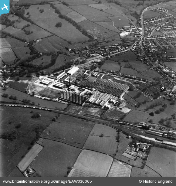
eaw036065 ENGLAND (1951). The Ferodo Ltd Sovereign Mills (Brake and Clutch Lining), Chapel-en-le-Frith, 1951. This image has been produced from a print.
© Copyright OpenStreetMap contributors and licensed by the OpenStreetMap Foundation. 2024. Cartography is licensed as CC BY-SA.
Nearby Images (29)
EAW036065
, Chapel-en-le-Frith, 1951. This image has been produced from a print.")
EAW036067
, Chapel-en-le-Frith, 1951. This image has been produced from a print.")
EAW036073
, Chapel-en-le-Frith, 1951. This image has been produced from a print.")
EAW036070
, Chapel-en-le-Frith, 1951. This image has been produced from a print.")
EAW036074
, Chapel-en-le-Frith, 1951. This image has been produced from a damaged print.")
EAW037091
, Chapel-en-le-Frith, 1951. This image has been produced from a print marked by Aerofilms Ltd for photo editing.")
EAW037082
, Chapel-en-le-Frith, 1951. This image has been produced from a print marked by Aerofilms Ltd for photo editing.")
EAW037092
, Chapel-en-le-Frith, 1951. This image has been produced from a print marked by Aerofilms Ltd for photo editing.")
EPW047286
, Chapel-en-le-Frith, 1935")
EAW036066
, Chapel-en-le-Frith, 1951. This image has been produced from a print.")
EAW037086
, Chapel-en-le-Frith, 1951. This image has been produced from a print marked by Aerofilms Ltd for photo editing.")
EAW037087
, Chapel-en-le-Frith, 1951. This image has been produced from a print marked by Aerofilms Ltd for photo editing.")
EPW047280
, Chapel-en-le-Frith, 1935")
EPW047281
, Chapel-en-le-Frith, 1935")
EAW036071
, Chapel-en-le-Frith, 1951. This image has been produced from a print.")
EPW047285
, Chapel-en-le-Frith, 1935")
EPW047284
, Chapel-en-le-Frith, 1935")
EPW047283
 and environs, Chapel-en-le-Frith, 1935")
EAW036064
, Chapel-en-le-Frith, 1951. This image has been produced from a print.")
EPW047282
 and environs, Chapel-en-le-Frith, 1935")
EAW037089
, Chapel-en-le-Frith, 1951. This image has been produced from a print marked by Aerofilms Ltd for photo editing.")
EAW036068
, Chapel-en-le-Frith, 1951. This image has been produced from a print.")
EAW037093
, Chapel-en-le-Frith, 1951. This image has been produced from a print marked by Aerofilms Ltd for photo editing.")
EAW037083
, Chapel-en-le-Frith, 1951. This image has been produced from a print marked by Aerofilms Ltd for photo editing.")
EAW037084
, Chapel-en-le-Frith, 1951. This image has been produced from a print marked by Aerofilms Ltd for photo editing.")
EAW036072
, Chapel-en-le-Frith, 1951. This image has been produced from a print.")
EAW037090
, Chapel-en-le-Frith, 1951. This image has been produced from a print marked by Aerofilms Ltd for photo editing.")
EAW037088
, Chapel-en-le-Frith, 1951. This image has been produced from a print marked by Aerofilms Ltd for photo editing.")
EAW037085
, Chapel-en-le-Frith, from the north-east, 1951. This image has been produced from a print marked by Aerofilms Ltd for photo editing.")
Details
| Title | [EAW036065] The Ferodo Ltd Sovereign Mills (Brake and Clutch Lining), Chapel-en-le-Frith, 1951. This image has been produced from a print. |
| Reference | EAW036065 |
| Date | 17-May-1951 |
| Link | |
| Place name | CHAPEL-EN-LE-FRITH |
| Parish | CHAPEL-EN-LE-FRITH |
| District | |
| Country | ENGLAND |
| Easting / Northing | 405776, 381142 |
| Longitude / Latitude | -1.9132680246578, 53.326894672367 |
| National Grid Reference | SK058811 |
Pins
Be the first to add a comment to this image!


