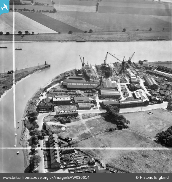
eaw030614 ENGLAND (1950). The Goole Shipbuilding and Repairing Co Ltd Works, Goole, 1950. This image was marked by Aerofilms Ltd for photo editing.
© Copyright OpenStreetMap contributors and licensed by the OpenStreetMap Foundation. 2025. Cartography is licensed as CC BY-SA.
Nearby Images (27)
Details
| Title | [EAW030614] The Goole Shipbuilding and Repairing Co Ltd Works, Goole, 1950. This image was marked by Aerofilms Ltd for photo editing. |
| Reference | EAW030614 |
| Date | 29-June-1950 |
| Link | |
| Place name | GOOLE |
| Parish | GOOLE |
| District | |
| Country | ENGLAND |
| Easting / Northing | 474826, 422745 |
| Longitude / Latitude | -0.86660316316727, 53.695552265063 |
| National Grid Reference | SE748227 |
Pins
Be the first to add a comment to this image!


![[EAW030614] The Goole Shipbuilding and Repairing Co Ltd Works, Goole, 1950. This image was marked by Aerofilms Ltd for photo editing.](http://britainfromabove.org.uk/sites/all/libraries/aerofilms-images/public/100x100/EAW/030/EAW030614.jpg)
![[EAW030608] The Goole Shipbuilding and Repairing Co Ltd Works, Goole, 1950](http://britainfromabove.org.uk/sites/all/libraries/aerofilms-images/public/100x100/EAW/030/EAW030608.jpg)
![[EAW030605] The Goole Shipbuilding and Repairing Co Ltd Works, Goole, 1950. This image was marked by Aerofilms Ltd for photo editing.](http://britainfromabove.org.uk/sites/all/libraries/aerofilms-images/public/100x100/EAW/030/EAW030605.jpg)
![[EAW030616] The Goole Shipbuilding and Repairing Co Ltd Works, Goole, 1950. This image was marked by Aerofilms Ltd for photo editing.](http://britainfromabove.org.uk/sites/all/libraries/aerofilms-images/public/100x100/EAW/030/EAW030616.jpg)
![[EAW030611] The Goole Shipbuilding and Repairing Co Ltd Works, Goole, 1950. This image was marked by Aerofilms Ltd for photo editing.](http://britainfromabove.org.uk/sites/all/libraries/aerofilms-images/public/100x100/EAW/030/EAW030611.jpg)
![[EAW030610] The Goole Shipbuilding and Repairing Co Ltd Works, Goole, 1950. This image was marked by Aerofilms Ltd for photo editing.](http://britainfromabove.org.uk/sites/all/libraries/aerofilms-images/public/100x100/EAW/030/EAW030610.jpg)
![[EAW030609] The Goole Shipbuilding and Repairing Co Ltd Works, Goole, 1950. This image was marked by Aerofilms Ltd for photo editing.](http://britainfromabove.org.uk/sites/all/libraries/aerofilms-images/public/100x100/EAW/030/EAW030609.jpg)
![[EAW030603] The Goole Shipbuilding and Repairing Co Ltd Works, Goole, 1950. This image was marked by Aerofilms Ltd for photo editing.](http://britainfromabove.org.uk/sites/all/libraries/aerofilms-images/public/100x100/EAW/030/EAW030603.jpg)
![[EPW031423] The Groves Ship Yard and Swinefleet Road, Old Goole, 1930](http://britainfromabove.org.uk/sites/all/libraries/aerofilms-images/public/100x100/EPW/031/EPW031423.jpg)
![[EAW030612] The Goole Shipbuilding and Repairing Co Ltd Works, Goole, 1950. This image was marked by Aerofilms Ltd for photo editing.](http://britainfromabove.org.uk/sites/all/libraries/aerofilms-images/public/100x100/EAW/030/EAW030612.jpg)
![[EAW030604] The Goole Shipbuilding and Repairing Co Ltd Works, Goole, 1950. This image was marked by Aerofilms Ltd for photo editing.](http://britainfromabove.org.uk/sites/all/libraries/aerofilms-images/public/100x100/EAW/030/EAW030604.jpg)
![[EAW030606] The Goole Shipbuilding and Repairing Co Ltd Works, Goole, 1950](http://britainfromabove.org.uk/sites/all/libraries/aerofilms-images/public/100x100/EAW/030/EAW030606.jpg)
![[EPW031445] The Groves, Goole Docks and the town, Goole, from the south-east, 1930](http://britainfromabove.org.uk/sites/all/libraries/aerofilms-images/public/100x100/EPW/031/EPW031445.jpg)
![[EAW030615] The Goole Shipbuilding and Repairing Co Ltd Works, Goole, 1950. This image was marked by Aerofilms Ltd for photo editing.](http://britainfromabove.org.uk/sites/all/libraries/aerofilms-images/public/100x100/EAW/030/EAW030615.jpg)
![[EAW030613] The Goole Shipbuilding and Repairing Co Ltd Works, Goole, 1950](http://britainfromabove.org.uk/sites/all/libraries/aerofilms-images/public/100x100/EAW/030/EAW030613.jpg)
![[EAW030607] The Goole Shipbuilding and Repairing Co Ltd Works, Goole, 1950. This image was marked by Aerofilms Ltd for photo editing.](http://britainfromabove.org.uk/sites/all/libraries/aerofilms-images/public/100x100/EAW/030/EAW030607.jpg)
![[EAW022512] Goole Harbour, Goole, from the south-east, 1949](http://britainfromabove.org.uk/sites/all/libraries/aerofilms-images/public/100x100/EAW/022/EAW022512.jpg)
![[EAW046156] Dutch River Mouth and the docks, Goole, 1952](http://britainfromabove.org.uk/sites/all/libraries/aerofilms-images/public/100x100/EAW/046/EAW046156.jpg)
![[EPW031449] The Groves, Goole Docks and the town, Goole, from the south-east, 1930](http://britainfromabove.org.uk/sites/all/libraries/aerofilms-images/public/100x100/EPW/031/EPW031449.jpg)
![[EAW022515] The harbour and town, Goole, from the south, 1949](http://britainfromabove.org.uk/sites/all/libraries/aerofilms-images/public/100x100/EAW/022/EAW022515.jpg)
![[EPW031447] Duckle's Buildings, Goole Docks and the town, Goole, from the south-east, 1930](http://britainfromabove.org.uk/sites/all/libraries/aerofilms-images/public/100x100/EPW/031/EPW031447.jpg)
![[EPW031444] The Dutch River Mouth, Goole Docks and the town, Goole, from the south-east, 1930](http://britainfromabove.org.uk/sites/all/libraries/aerofilms-images/public/100x100/EPW/031/EPW031444.jpg)
![[EPW031446] The Dutch River Mouth, Goole Docks and the town, Goole, from the south-east, 1930](http://britainfromabove.org.uk/sites/all/libraries/aerofilms-images/public/100x100/EPW/031/EPW031446.jpg)
![[EAW046153] The docks and River Ouse, Goole, 1952](http://britainfromabove.org.uk/sites/all/libraries/aerofilms-images/public/100x100/EAW/046/EAW046153.jpg)
![[EPW031452] The Dutch River Mouth, Goole Docks and the town, Goole, from the east, 1930](http://britainfromabove.org.uk/sites/all/libraries/aerofilms-images/public/100x100/EPW/031/EPW031452.jpg)
![[EPW031422] Field House and housing off Percy Street, Old Goole, 1930](http://britainfromabove.org.uk/sites/all/libraries/aerofilms-images/public/100x100/EPW/031/EPW031422.jpg)
![[EPW048854] The Dutch River Mouth and Goole Docks, Goole, 1935](http://britainfromabove.org.uk/sites/all/libraries/aerofilms-images/public/100x100/EPW/048/EPW048854.jpg)