
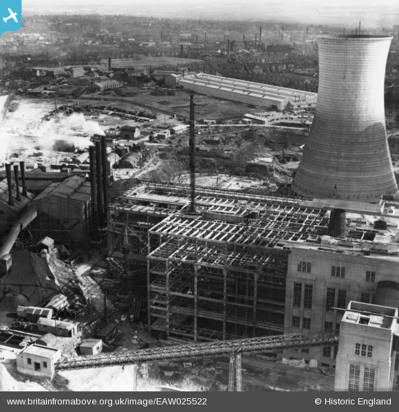
eaw025522 ENGLAND (1949). Walsall B Power Station under construction, Walsall, from the north, 1949. This image has been produced from a print.
© Copyright OpenStreetMap contributors and licensed by the OpenStreetMap Foundation. 2024. Cartography is licensed as CC BY-SA.
Nearby Images (48)
EAW025525

EAW020822

EAW025505

EAW017216

EAW025504

EAW008396

EAW020823

EAW008397

EAW020821

EAW025523

EAW020828

EAW017213

EAW017220

EAW017221

EAW020827

EAW008393

EAW017212

EAW017211

EAW025508

EAW017219
, Walsall, 1948. This image has been produced from a damaged negative.")
EAW017215

EAW020818

EAW020831

EAW025517

EAW017218

EAW020830

EAW008391

EAW008399

EAW020832

EAW008392

EAW025507

EAW020824

EAW008402

EAW020826

EAW025516

EAW008398

EAW013443

EAW020815

EAW008400

EAW025512

EAW025503

EAW029330

EAW013444

EAW012898

EAW020817

EAW008401

EAW025515

EAW012899

Details
| Title | [EAW025522] Walsall B Power Station under construction, Walsall, from the north, 1949. This image has been produced from a print. |
| Reference | EAW025522 |
| Date | 3-August-1949 |
| Link | |
| Place name | WALSALL |
| Parish | |
| District | |
| Country | ENGLAND |
| Easting / Northing | 400191, 299896 |
| Longitude / Latitude | -1.9971798886915, 52.596502207483 |
| National Grid Reference | SP002999 |
Pins
Be the first to add a comment to this image!


