
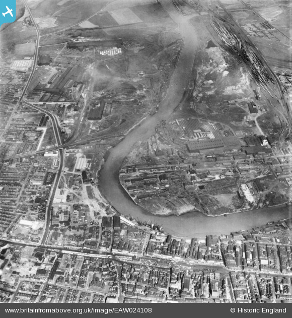
eaw024108 ENGLAND (1949). The industrial area along the River Tees, Thornaby-on-Tees, 1949. This image has been produced from a print.
© Copyright OpenStreetMap contributors and licensed by the OpenStreetMap Foundation. 2024. Cartography is licensed as CC BY-SA.
Nearby Images (3)
EAW024108

EAW013851

EPW010281

Details
| Title | [EAW024108] The industrial area along the River Tees, Thornaby-on-Tees, 1949. This image has been produced from a print. |
| Reference | EAW024108 |
| Date | 22-June-1949 |
| Link | |
| Place name | THORNABY-ON-TEES |
| Parish | THORNABY |
| District | |
| Country | ENGLAND |
| Easting / Northing | 445072, 519061 |
| Longitude / Latitude | -1.3028577789784, 54.564643156361 |
| National Grid Reference | NZ451191 |
Pins
 Fred Starr |
Thursday 3rd of November 2022 06:48:45 PM | |
J May |
Tuesday 2nd of June 2015 01:27:50 PM | |
J May |
Tuesday 2nd of June 2015 01:24:14 PM | |
J May |
Wednesday 12th of November 2014 10:01:15 PM | |
J May |
Wednesday 12th of November 2014 09:57:41 PM | |
J May |
Wednesday 12th of November 2014 09:55:24 PM | |
J May |
Wednesday 12th of November 2014 09:52:47 PM | |
J May |
Wednesday 12th of November 2014 09:51:56 PM | |
J May |
Wednesday 12th of November 2014 09:51:06 PM | |
J May |
Wednesday 12th of November 2014 09:50:25 PM | |
J May |
Wednesday 12th of November 2014 09:49:33 PM | |
J May |
Wednesday 12th of November 2014 09:48:44 PM | |
J May |
Wednesday 12th of November 2014 09:46:54 PM |


