
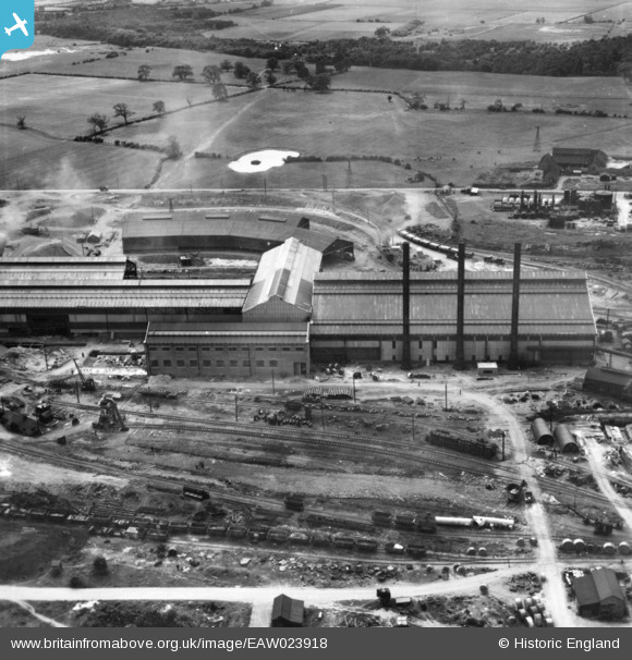
eaw023918 ENGLAND (1949). Part of the John Lysaght Normanby Park Steel Works, Scunthorpe, 1949. This image has been produced from a print.
© Copyright OpenStreetMap contributors and licensed by the OpenStreetMap Foundation. 2024. Cartography is licensed as CC BY-SA.
Nearby Images (48)
EAW028576

EAW041838

EAW031180

EAW013495

EAW031179

EAW034820

EAW041834

EAW009627

EAW041836

EAW041829

EAW009623

EAW041833

EAW021129

EAW016665

EAW038770

EAW034798

EAW009413

EAW031177

EAW049664

EAW019665

EAW041835

EAW013494

EAW031169

EAW031171

EAW034807

EAW038747

EAW021141
, Scunthorpe, 1949. This image has been produced from a damaged negative.")
EAW027167

EAW034803

EAW013496

EAW038749

EAW023920

EAW021140

EAW038769

EAW009414

EAW013491

EAW041831

EAW016663

EAW038764

EAW038768

EAW034802

EAW034825

EAW049667

EAW019677

EAW016666

EAW038760

EAW009639

EAW038763

Details
| Title | [EAW023918] Part of the John Lysaght Normanby Park Steel Works, Scunthorpe, 1949. This image has been produced from a print. |
| Reference | EAW023918 |
| Date | 20-June-1949 |
| Link | |
| Place name | SCUNTHORPE |
| Parish | |
| District | |
| Country | ENGLAND |
| Easting / Northing | 489009, 413367 |
| Longitude / Latitude | -0.65451833187653, 53.609049729416 |
| National Grid Reference | SE890134 |
Pins
 redmist |
Friday 1st of February 2019 02:11:45 PM |


