
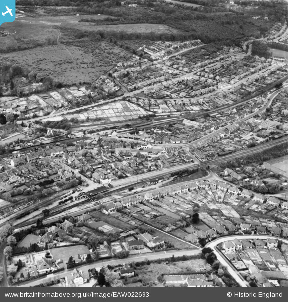
eaw022693 ENGLAND (1949). The town around Whtyeleafe Railway Station and Upper Warlingham Railway Station, Whyteleafe, 1949
© Copyright OpenStreetMap contributors and licensed by the OpenStreetMap Foundation. 2024. Cartography is licensed as CC BY-SA.
Details
| Title | [EAW022693] The town around Whtyeleafe Railway Station and Upper Warlingham Railway Station, Whyteleafe, 1949 |
| Reference | EAW022693 |
| Date | 25-April-1949 |
| Link | |
| Place name | WHYTELEAFE |
| Parish | WHYTELEAFE |
| District | |
| Country | ENGLAND |
| Easting / Northing | 533921, 158489 |
| Longitude / Latitude | -0.078404566184993, 51.309232805376 |
| National Grid Reference | TQ339585 |
Pins
 Tony74 |
Thursday 23rd of June 2022 11:36:09 AM | |
JRA |
Sunday 13th of March 2016 04:26:15 PM | |
Tony74 |
Wednesday 8th of October 2014 10:07:24 AM | |
Tony74 |
Wednesday 8th of October 2014 10:01:01 AM | |
Tony74 |
Tuesday 7th of October 2014 12:53:03 AM | |
Tony74 |
Tuesday 7th of October 2014 12:36:56 AM | |
Tony74 |
Tuesday 7th of October 2014 12:33:44 AM | |
Tony74 |
Tuesday 7th of October 2014 12:32:27 AM | |
Tony74 |
Monday 6th of October 2014 03:07:58 PM | |
Tony74 |
Monday 6th of October 2014 03:06:52 PM | |
totoro |
Monday 24th of February 2014 10:01:42 PM | |
totoro |
Monday 24th of February 2014 09:56:50 PM | |
totoro |
Monday 24th of February 2014 09:54:02 PM | |
totoro |
Monday 24th of February 2014 09:53:06 PM | |
totoro |
Monday 24th of February 2014 09:48:28 PM | |
totoro |
Monday 24th of February 2014 09:40:11 PM | |
totoro |
Monday 24th of February 2014 09:29:27 PM | |
totoro |
Monday 24th of February 2014 09:28:24 PM | |
totoro |
Monday 24th of February 2014 09:28:05 PM | |
totoro |
Monday 24th of February 2014 09:27:24 PM | |
totoro |
Monday 24th of February 2014 09:26:37 PM | |
totoro |
Monday 24th of February 2014 09:24:12 PM | |
totoro |
Monday 24th of February 2014 09:23:37 PM | |
totoro |
Monday 24th of February 2014 09:21:47 PM | |
totoro |
Monday 24th of February 2014 09:21:18 PM | |
totoro |
Monday 24th of February 2014 09:20:49 PM | |
totoro |
Monday 24th of February 2014 09:19:31 PM | |
cptpies |
Wednesday 18th of December 2013 12:35:43 PM |


