
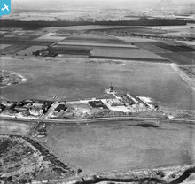
eaw022004 ENGLAND (1949). Barton Aerodrome (City Airport Manchester), Irlam, 1949. This image has been produced from a print.

© Copyright OpenStreetMap contributors and licensed by the OpenStreetMap Foundation. 2024. Cartography is licensed as CC BY-SA.
Nearby Images (2)
EAW022004
, Irlam, 1949. This image has been produced from a print.")
EPW032681

Details
| Title | [EAW022004] Barton Aerodrome (City Airport Manchester), Irlam, 1949. This image has been produced from a print. |
| Reference | EAW022004 |
| Date | 14-April-1949 |
| Link | |
| Place name | IRLAM |
| Parish | |
| District | |
| Country | ENGLAND |
| Easting / Northing | 374385, 397161 |
| Longitude / Latitude | -2.3859290566699, 53.470307661721 |
| National Grid Reference | SJ744972 |
Pins
 Saul |
Saturday 28th of October 2023 03:54:34 PM | |
 Matt Aldred edob.mattaldred.com |
Friday 17th of March 2023 03:13:21 PM | |
Matt Aldred edob.mattaldred.com |
Friday 17th of March 2023 03:13:08 PM | |
redmist |
Monday 23rd of January 2023 10:53:29 PM | |
redmist |
Wednesday 26th of December 2018 06:01:43 PM | |
SteveTamburello |
Monday 26th of February 2018 01:42:25 PM | |
 clippedwings |
Friday 18th of December 2015 10:19:15 PM | |
cptpies |
Monday 6th of October 2014 08:45:50 AM | |
cptpies |
Monday 6th of October 2014 08:45:29 AM |
User Comment Contributions
 Air Raid Shelters at Barton Aerodrome. |
cptpies |
Monday 6th of October 2014 08:46:44 AM |


