
eaw019511 ENGLAND (1948) [Unlocated]. UNLOCATED. This image has been produced from a print.
© Copyright OpenStreetMap contributors and licensed by the OpenStreetMap Foundation. 2024. Cartography is licensed as CC BY-SA.
Nearby Images (48)
EPW000143

EPW000667

EPW005260

EPW006389
, 1921")
EPW007181

EPW015853

EPW015854

EPW015855

EPW016012

EPW016510

EPW016641

EPW017028

EPW017029

EPW017136

SAW003585

SAW003586

SAW009337

SAW009800

SAW009801

SAW009802

SAW010734

SAW014737

SAW017926

SAW017927

SAW032504

SPW020275

SPW020280

SPW020281

SPW020284

SPW020632

SPW020633

SPW027083

SPW049776

SPW049777

SPW049779

SPW049783

SPW049791

SPW049798

SPW049801

SPW049827

SPW049828

SPW049831

SPW049832

SPW049834

SPW049948

SPW049949

SPW051009

SPW062638

Details
| Title | [EAW019511] UNLOCATED. This image has been produced from a print. |
| Reference | EAW019511 |
| Date | 5-October-1948 |
| Link | |
| Place name | |
| Parish | |
| District | |
| Country | ENGLAND |
| Easting / Northing | 0, 0 |
| Longitude / Latitude | -7.556448482059, 49.766185796754 |
| National Grid Reference | SV000000 |
Pins
 ewnmcg |
Monday 15th of September 2014 07:23:14 PM | |
ewnmcg |
Monday 15th of September 2014 07:15:42 PM | |
ewnmcg |
Monday 15th of September 2014 07:14:37 PM | |
ewnmcg |
Monday 15th of September 2014 07:13:24 PM | |
ewnmcg |
Monday 15th of September 2014 07:10:41 PM | |
ewnmcg |
Monday 15th of September 2014 07:00:53 PM | |
ewnmcg |
Monday 15th of September 2014 06:58:43 PM | |
ewnmcg |
Monday 15th of September 2014 06:56:08 PM | |
ewnmcg |
Monday 15th of September 2014 06:55:31 PM | |
ewnmcg |
Monday 15th of September 2014 06:52:55 PM | |
ewnmcg |
Monday 15th of September 2014 06:43:20 PM | |
ewnmcg |
Monday 15th of September 2014 06:38:38 PM |
User Comment Contributions
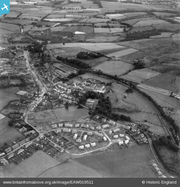
It is Lennoxtown and, sad to admit it, it is but a stone's throw from where I live. HOW did I not spot it right away? Anyway, back with some more info soon. |
ewnmcg |
Wednesday 17th of September 2014 02:02:20 PM |
Just noticed that this one has been solved by ewnmcg Well Done. I thought that it was in Scotland but Scotland is a big country and I couldn't look everywhere. I thought it might have been on the Great North of Scotland system but I couldn't find it so I gave up to look at other more profitable prospects. Once again ewnmcg Well Done and I hope you can identify one or two of the remaining pictures. |
 Class31 |
Wednesday 17th of September 2014 02:02:20 PM |
Grid Ref for Lennoxtown 'centre' is NS 62940 77600. |
ewnmcg |
Monday 15th of September 2014 07:09:08 PM |
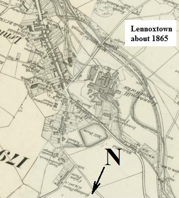 Lennoxtown as about 1865 - rotated to be close to direction of aerial image. |
ewnmcg |
Monday 15th of September 2014 06:36:13 PM |
The architecture looks Scottish! |
Class31 |
Monday 15th of September 2014 06:12:49 PM |
Or Irish! |
Class31 |
Thursday 11th of September 2014 08:52:42 AM |
Thanks you Class 31 - you just didn't give me any clue as to which railway company was operating here. Aye, it is Scottish. |
ewnmcg |
Monday 15th of September 2014 06:12:49 PM |


