
eaw018571 ENGLAND (1948) [Unlocated]. UNLOCATED. This image has been produced from a print.
© Copyright OpenStreetMap contributors and licensed by the OpenStreetMap Foundation. 2024. Cartography is licensed as CC BY-SA.
Nearby Images (48)
EPW000143

EPW000667

EPW005260

EPW006389
, 1921")
EPW007181

EPW015853

EPW015854

EPW015855

EPW016012

EPW016510

EPW016641

EPW017028

EPW017029

EPW017136

SAW003585

SAW003586

SAW009337

SAW009800

SAW009801

SAW009802

SAW010734

SAW014737

SAW017926

SAW017927

SAW032504

SPW020275

SPW020280

SPW020281

SPW020284

SPW020632

SPW020633

SPW027083

SPW049776

SPW049777

SPW049779

SPW049783

SPW049791

SPW049798

SPW049801

SPW049827

SPW049828

SPW049831

SPW049832

SPW049834

SPW049948

SPW049949

SPW051009

SPW062638

Details
| Title | [EAW018571] UNLOCATED. This image has been produced from a print. |
| Reference | EAW018571 |
| Date | 9-September-1948 |
| Link | |
| Place name | |
| Parish | |
| District | |
| Country | ENGLAND |
| Easting / Northing | 0, 0 |
| Longitude / Latitude | -7.556448482059, 49.766185796754 |
| National Grid Reference | SV000000 |
Pins

User Comment Contributions
Next photo is Rochester so probably Kent side of the Weald |
 TomRobin |
Tuesday 25th of November 2014 10:37:17 AM |
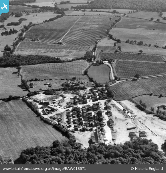
With architectural style golf, timber yards and orchards, I think we are looking at the Weald area. |
TomRobin |
Tuesday 25th of November 2014 10:35:07 AM |
Same location as EAW018570. |
Tony D |
Sunday 19th of October 2014 09:54:25 AM |
Orchards in the background? Looks like milled timber - saw mill? |
longinthetooth |
Monday 8th of September 2014 02:10:56 PM |


