
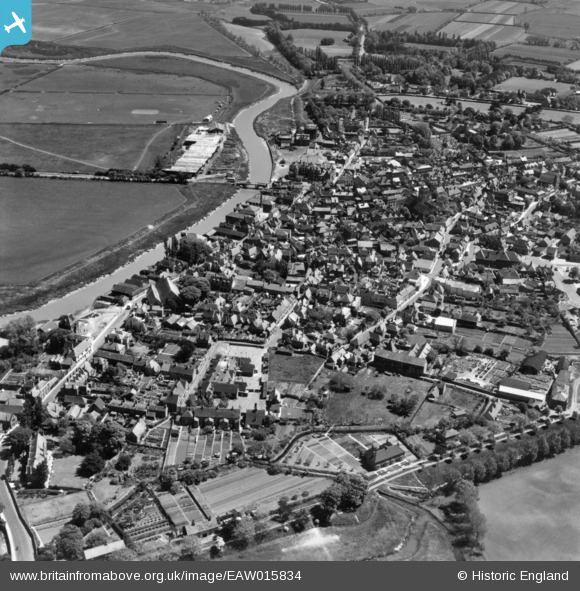
eaw015834 ENGLAND (1948). The town, Sandwich, 1948. This image has been produced from a print.
© Copyright OpenStreetMap contributors and licensed by the OpenStreetMap Foundation. 2024. Cartography is licensed as CC BY-SA.
Nearby Images (8)
EAW015834

EPW013243

EPW013244

EPW013240

EPW035443

EPW013241

EPW000655

EPW035444

Details
| Title | [EAW015834] The town, Sandwich, 1948. This image has been produced from a print. |
| Reference | EAW015834 |
| Date | 19-May-1948 |
| Link | |
| Place name | SANDWICH |
| Parish | SANDWICH |
| District | |
| Country | ENGLAND |
| Easting / Northing | 632961, 158324 |
| Longitude / Latitude | 1.3405436210596, 51.275844125356 |
| National Grid Reference | TR330583 |
Pins
 Dave L |
Sunday 8th of February 2015 09:21:09 PM | |
Dave L |
Sunday 8th of February 2015 09:20:04 PM | |
Dave L |
Sunday 8th of February 2015 09:19:19 PM | |
Dave L |
Sunday 8th of February 2015 09:18:38 PM | |
Dave L |
Sunday 8th of February 2015 09:18:04 PM |
User Comment Contributions
 United Reformed Church Sandwich 2014 |
 Alan McFaden |
Friday 31st of October 2014 09:35:34 AM |
 Saint Peter's Church Sandwich 2014 |
Alan McFaden |
Friday 31st of October 2014 09:35:03 AM |
 Sandwich Toll Gate 2014 |
Alan McFaden |
Friday 31st of October 2014 09:34:30 AM |


