
eaw006760 ENGLAND (1947). The Wrekin Brewery, Wellington, 1947

© Copyright OpenStreetMap contributors and licensed by the OpenStreetMap Foundation. 2025. Cartography is licensed as CC BY-SA.
Nearby Images (11)
EAW006760

EAW006759

EAW006761

EAW010852

EAW006804

EAW006802

EAW006803

EPW034033

EAW006814

EAW006813

EAW006815

Details
| Title | [EAW006760] The Wrekin Brewery, Wellington, 1947 |
| Reference | EAW006760 |
| Date | 28-May-1947 |
| Link | |
| Place name | WELLINGTON |
| Parish | WELLINGTON |
| District | |
| Country | ENGLAND |
| Easting / Northing | 364931, 311570 |
| Longitude / Latitude | -2.5190227535001, 52.700324252076 |
| National Grid Reference | SJ649116 |
Pins
Lynda Tubbs |
Tuesday 22nd of April 2014 02:03:04 PM | |
 MB |
Friday 21st of February 2014 10:14:50 AM | |
MB |
Friday 21st of February 2014 10:13:53 AM |
User Comment Contributions
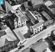 The Wrekin Brewery, Wellington. |
Sarah Hoile |
Wednesday 21st of May 2014 11:57:16 PM |
some history of the Wrekin Brewery: http://www.wellingtonla21.org.uk/discover/wrekinbrewery.html |
Andrew Bennett |
Wednesday 21st of May 2014 11:57:16 PM |