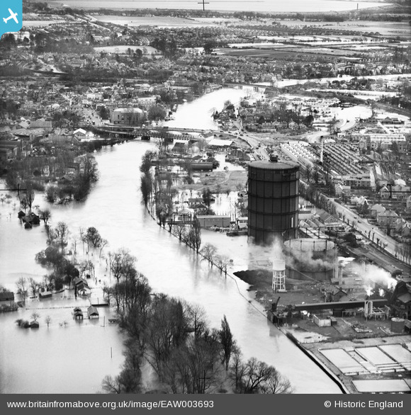
eaw003693 ENGLAND (1947). The River Thames in flood around the town Gas Works and Staines Bridge, Egham, 1947
© Copyright OpenStreetMap contributors and licensed by the OpenStreetMap Foundation. 2024. Cartography is licensed as CC BY-SA.
Nearby Images (2)
EAW003693

EPW023484

Details
| Title | [EAW003693] The River Thames in flood around the town Gas Works and Staines Bridge, Egham, 1947 |
| Reference | EAW003693 |
| Date | 18-March-1947 |
| Link | |
| Place name | EGHAM |
| Parish | |
| District | |
| Country | ENGLAND |
| Easting / Northing | 502836, 171628 |
| Longitude / Latitude | -0.52044848537478, 51.433816722363 |
| National Grid Reference | TQ028716 |
Pins
 Spy Man |
Saturday 9th of April 2022 04:55:49 PM | |
 Class31 |
Tuesday 8th of September 2015 07:43:30 PM | |
Class31 |
Tuesday 8th of September 2015 07:41:42 PM | |
Graham Yaxley |
Monday 15th of December 2014 10:49:36 PM | |
ABC not Odeon |
CLeigh |
Tuesday 15th of December 2015 04:41:03 PM |
JOHNAA |
Tuesday 19th of November 2013 10:58:01 PM | |
JOHNAA |
Tuesday 19th of November 2013 10:57:12 PM | |
The nearer bridge is not in the 1928 images, therefore, it is likely to have been temporary while the bomb-damaged bridge was repaired |
Graham Yaxley |
Monday 15th of December 2014 10:47:56 PM |
JOHNAA |
Tuesday 19th of November 2013 10:54:28 PM |