
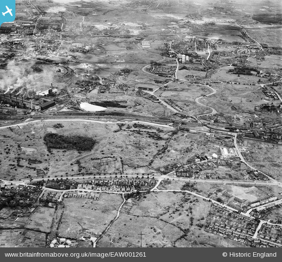
eaw001261 ENGLAND (1946). The industrial and residential area at Deepfields and Lady Moor, Bilston, 1946
© Copyright OpenStreetMap contributors and licensed by the OpenStreetMap Foundation. 2024. Cartography is licensed as CC BY-SA.
Details
| Title | [EAW001261] The industrial and residential area at Deepfields and Lady Moor, Bilston, 1946 |
| Reference | EAW001261 |
| Date | 24-June-1946 |
| Link | |
| Place name | BILSTON |
| Parish | |
| District | |
| Country | ENGLAND |
| Easting / Northing | 393935, 295098 |
| Longitude / Latitude | -2.0894617050002, 52.553330281603 |
| National Grid Reference | SO939951 |
Pins
 GaryGareth |
Tuesday 2nd of November 2021 07:25:33 PM | |
 NMD |
Thursday 28th of October 2021 06:55:48 PM | |
Mark |
Wednesday 29th of July 2020 06:16:16 PM | |
Des |
Monday 17th of June 2019 08:19:10 PM | |
Des |
Monday 17th of June 2019 08:18:20 PM | |
paul |
Monday 8th of August 2016 12:26:52 AM | |
paul |
Monday 8th of August 2016 12:23:57 AM | |
paul |
Monday 8th of August 2016 12:17:35 AM | |
paul |
Sunday 7th of August 2016 11:30:08 PM | |
paul |
Sunday 7th of August 2016 05:07:41 PM | |
paul |
Sunday 7th of August 2016 05:04:43 PM | |
paul |
Sunday 7th of August 2016 04:57:38 PM | |
paul |
Sunday 7th of August 2016 04:55:44 PM | |
paul |
Sunday 7th of August 2016 04:53:43 PM | |
paul |
Sunday 7th of August 2016 04:45:33 PM | |
Des |
Saturday 6th of February 2016 03:47:21 PM | |
Des |
Saturday 6th of February 2016 03:47:21 PM | |
Des |
Saturday 6th of February 2016 03:47:20 PM | |
MetalMike |
Tuesday 20th of January 2015 08:36:21 PM | |
dbm |
Wednesday 29th of October 2014 01:06:42 AM | |
dbm |
Wednesday 29th of October 2014 01:04:55 AM | |
dbm |
Wednesday 29th of October 2014 01:00:29 AM | |
dbm |
Wednesday 29th of October 2014 12:58:53 AM | |
dbm |
Wednesday 29th of October 2014 12:57:50 AM | |
dbm |
Wednesday 29th of October 2014 12:56:46 AM | |
dbm |
Wednesday 29th of October 2014 12:54:34 AM | |
dbm |
Wednesday 29th of October 2014 12:48:14 AM | |
dbm |
Wednesday 29th of October 2014 12:46:35 AM | |
dbm |
Monday 27th of October 2014 10:29:20 PM | |
dbm |
Monday 27th of October 2014 10:25:17 PM | |
dbm |
Monday 27th of October 2014 10:23:12 PM | |
dbm |
Monday 27th of October 2014 10:21:17 PM | |
dbm |
Monday 27th of October 2014 10:19:55 PM | |
dbm |
Monday 27th of October 2014 10:18:39 PM | |
dbm |
Monday 27th of October 2014 10:18:02 PM | |
dbm |
Monday 27th of October 2014 10:16:15 PM | |
dbm |
Monday 27th of October 2014 10:11:37 PM | |
dbm |
Monday 27th of October 2014 10:10:37 PM | |
dbm |
Monday 27th of October 2014 10:09:23 PM | |
dbm |
Monday 27th of October 2014 01:45:25 PM | |
dbm |
Monday 27th of October 2014 01:43:27 PM | |
dbm |
Monday 27th of October 2014 01:41:32 PM | |
gaz |
Saturday 25th of January 2014 09:50:34 PM | |
Does anyone know anything of Highfield Colliery, by Highfield Rd? |
Natalie |
Wednesday 24th of December 2014 09:32:20 AM |


