
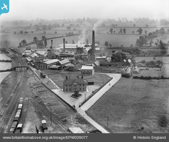
EPW039077 ENGLAND (1932). The Southam Cement Works and Cuttle Farm, Long Itchington, from the west, 1932
© Copyright OpenStreetMap contributors and licensed by the OpenStreetMap Foundation. 2024. Cartography is licensed as CC BY-SA.
Nearby Images (3)
EPW039077

EPW039082

EPW039083

Details
| Title | [EPW039077] The Southam Cement Works and Cuttle Farm, Long Itchington, from the west, 1932 |
| Reference | EPW039077 |
| Date | July-1932 |
| Link | |
| Place name | LONG ITCHINGTON |
| Parish | LONG ITCHINGTON |
| District | |
| Country | ENGLAND |
| Easting / Northing | 441969, 264125 |
| Longitude / Latitude | -1.3848427804524, 52.273280220177 |
| National Grid Reference | SP420641 |
Pins
 Dylan Moore |
Friday 13th of February 2015 01:03:41 PM | |
Dylan Moore |
Friday 13th of February 2015 01:02:23 PM | |
Dylan Moore |
Friday 13th of February 2015 01:01:54 PM | |
Dylan Moore |
Friday 13th of February 2015 01:01:19 PM | |
Dylan Moore |
Friday 13th of February 2015 01:00:19 PM | |
Dylan Moore |
Friday 13th of February 2015 12:55:35 PM | |
Dylan Moore |
Friday 13th of February 2015 12:53:59 PM | |
Dylan Moore |
Saturday 13th of December 2014 09:20:58 PM | |
 Ian Robinson |
Monday 24th of December 2012 05:34:57 PM | |
Ian Robinson |
Monday 24th of December 2012 05:33:33 PM | |
Dylan Moore |
Monday 10th of December 2012 09:03:57 PM |
User Comment Contributions
The old-established firm of Kaye's operated the Southam cement plant. The company was taken over by Rugby Portland Cement in 1934. The plant as shown here could make around 70,000 tonnes of cement a year. The plant was refurbished in 1938, and steadily grew until by the 1970s it could make 600,000 tonnes a year. It finally shut down in February 2000. |
Dylan Moore |
Monday 10th of December 2012 09:10:43 PM |


