
Groups

Natural Features
About the group Images of themed natural features
Created 5 December 2012

AlMu |
||
|
Glen Rosa is a good example of the action of Glaciation on the landscape of Scotland. In the past, a thick layer of ice covered the country and when the resulting glaciers slowly flowed downhill, the immense weight of ice that they carried gradually carved out the characteristic 'U-shaped valley' structures that can be seen today all over the Scottish Highlands. The U-shape is evident in this image, taken looking up the glen.
|
AlMu |
|
|
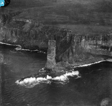
The Old Man of Hoy rises for nearly 450 feet off the West coast of the island of Hoy, which is part of the Orkney Islands archipelago. The Old May is a good example of a 'sea-stack' - that is, a column of rock which was originally part of the mainland behind it, but which has been eroded by the sea. This first forms a natural rock arch and then (when the roof of the arch collapses)leaves behind the outer buttress of the arch as a sea-stack, as we see here. Other Scottish examples include the Old Man of Stoer and Am Buchaille in Sandwood Bay, both off the West coast of Sutherland
|
AlMu |
|
|
Coastlines are dynamic features, changing over time as sea levels rise and fall, and as coastal erosion carries away material from the land. This can be seen clearly in this images, as the sharp edge of the higher land gives way to the eroding slope of the coastline leading down to the sea.
|
AlMu |
|
|
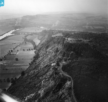
Kinnoull Hill is a good example of a 'scarp' feature - that is, a sudden change in the relative height of a landform, due to geological factors (in this case, a volcanic magma flow that has resisted weathering).
|
AlMu |
|
|
The River Stour can be seen in this wide valley. It has taken a winding course, over a long period of time, forming great U shaped meanders (bends). Some of these meanders have then formed into oxbow lakes. The river has taken a new course across the neck of the 'U' and detached the meander from the river to become a lake.
|
MM |
|
|
Many seaside towns sit high above the sea on top of cliffs, as seen here at Shanklin. As they have been developed for tourists many have had to find a way to help people to move between the beach and town without having a steep climb. Lifts, such as this one, were installed in several seaside towns. The first lift in Shanklin was built in 1892 leading directly to the pier that had been built the year before. The pier has not survived to the present day but there is still a lift in operation (2014). Check out some more seaside towns with cliffs at http://www.heritage-explorer.co.uk/web/he/search.aspx?crit=seaside%2C%20cliff&rt=0
|
MM |
|
|
Many towns were first built on rivers at a place where it was possible to cross. London was one example. The city of Worcester started as a Roman settlement at a crossing point on the river Severn. A medieval stone bridge was replaced with the present one in 1781.
|
MM |
|
|
At 4,409 feet (1344 metres) Ben Nevis is the highest mountain in Britain. Its geology is volcanic and catastrophic - it is essentially the remains of a large volcano that imploded in the Devonian period, leaving a mixture of granite and basalt which was then extensively eroded by glaciation.
Ben Nevis attractes thousands of walkers every year, who take the well-worn 'tourist' path to its summit, and has some of the finest and most challenging summer and winter rock-climbing routes in the country. It has also been the site of many fatalities, owing to the complex topography of its summit plateau. |
AlMu |
|
 |
AlMu |


see image record