
epw033331 ENGLAND (1930). The Park Prewett Hospital, Basingstoke, 1930

© Copyright OpenStreetMap contributors and licensed by the OpenStreetMap Foundation. 2024. Cartography is licensed as CC BY-SA.
Details
| Title | [EPW033331] The Park Prewett Hospital, Basingstoke, 1930 |
| Reference | EPW033331 |
| Date | July-1930 |
| Link | |
| Place name | BASINGSTOKE |
| Parish | ROOKSDOWN |
| District | |
| Country | ENGLAND |
| Easting / Northing | 461486, 153932 |
| Longitude / Latitude | -1.1183295223206, 51.28069896365 |
| National Grid Reference | SU615539 |
Pins
 mapsmith |
Monday 30th of November 2020 03:02:38 PM | |
mapsmith |
Monday 30th of November 2020 02:57:58 PM | |
 clippedwings |
Monday 30th of June 2014 11:18:22 AM | |
Dan Gregory |
Wednesday 4th of June 2014 04:14:56 PM | |
Dan Gregory |
Wednesday 4th of June 2014 04:14:22 PM | |
Dan Gregory |
Wednesday 4th of June 2014 04:13:41 PM | |
Dan Gregory |
Wednesday 4th of June 2014 04:12:52 PM | |
Dan Gregory |
Wednesday 4th of June 2014 04:12:18 PM | |
Dan Gregory |
Wednesday 4th of June 2014 04:11:13 PM |
User Comment Contributions
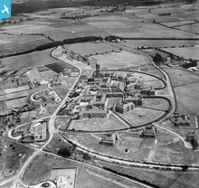 Hampshire County Mental Hospital, compact arrow design by G.T. Hine, 1910-1917. Requisitioned as the No. 4 Canadian General Hospital in 1917 and finally opened to psychiatric patients in 1921. Closed in 1997 with some buildings retained as apartments. Further reading: http://thetimechamber.co.uk/beta/sites/asylums/park-prewett-county-asylum-basingstoke http://www.victoriacountyhistory.ac.uk/explore/items/park-prewett-hospital-basingstoke |
Dan Gregory |
Wednesday 4th of June 2014 04:16:03 PM |
This area is now one of the new Rooksdown Housing estate in Basingstoke. Most of the main buildings in this shot have been demolished but the tower has been retained. |
Mark Herriott |
Sunday 17th of November 2013 06:58:01 PM |


