
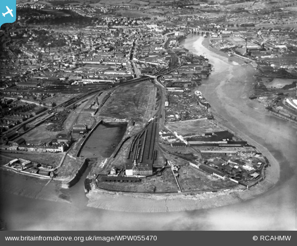
WPW055470 WALES (1937). View of Newport showing town dock and warehouses, oblique aerial view. 5"x4" black and white glass plate negative.
© Copyright OpenStreetMap contributors and licensed by the OpenStreetMap Foundation. 2024. Cartography is licensed as CC BY-SA.
Details
| Title | [WPW055470] View of Newport showing town dock and warehouses, oblique aerial view. 5"x4" black and white glass plate negative. |
| Reference | WPW055470 |
| Date | 15-September-1937 |
| Link | Coflein Archive Item 6370132 |
| Place name | |
| Parish | |
| District | |
| Country | WALES |
| Easting / Northing | 332070, 187005 |
| Longitude / Latitude | -2.9804037867402, 51.577336308292 |
| National Grid Reference | ST321870 |
Pins
 Monty |
Monday 24th of July 2017 05:21:39 PM | |
gBr |
Tuesday 9th of December 2014 09:06:37 PM | |
gBr |
Tuesday 9th of December 2014 09:03:11 PM | |
Louis |
Saturday 19th of January 2013 03:39:33 PM | |
Louis |
Saturday 19th of January 2013 03:37:43 PM | |
I believe that large numbers of redundant steam (and some diesel) locomotives were scrapped at Cashmores, Newport - especially in the sixties, and possibly later. Would that work have been done at this site too, and was there still rail access to it after the old MRCC line was dismantled? |
czyrko |
Friday 27th of December 2013 06:16:33 PM |
Yes there was rail access and a large coal distribution area on the town side of the octopus bridge right up to the time the yard closed. In 1966 there were lines of SR Merchant Navy class locos outside the wall of the yard awaiting scrapping. The line came from Maes Glas across Corporation Road via a level crossing and around to the remaining wharfs on the river side. Part of this line now forms the Hospital Car Park. |
Louis |
Wednesday 27th of August 2014 04:19:20 PM |
Cronin |
Sunday 5th of August 2012 02:54:02 PM | |
Cronin |
Sunday 5th of August 2012 02:45:14 PM |
User Comment Contributions
Nice view of the early town dock. A large ship is berthed at Cashmores yard in the process of being cut up. Date is probably late 1930s as the new Kingsway road, which was completed in 1934, is shown up to Old Green crossing in the distance. The south dock is at low tide and looks to be operational. I think the north dock was taken out of use and filled in 1930. |
Ray |
Friday 27th of December 2013 06:33:30 PM |
The dock in view is the original Old (or Old Town) Dock comprising two basins - north and south. Built in two stages in 1842 (south) and 1858 (north). It finally closed on 11/10/30, the lock gates fixed open so it became solely tidal - this is what we can see here. The original basin was filled in at the start of the war. At least that's what John Hutton says in his history of the dock's railways ISBN 1 85794 163 2 |
czyrko |
Friday 27th of December 2013 06:33:30 PM |
 Old Town Dock and River Usk, Newport |
 owain |
Monday 2nd of July 2012 08:19:21 AM |
I've been looking for a photograph of Alexandra Dock, Newport. Would this be it? It says town dock but no name or is Town Dock the name? |
DeborahWales |
Monday 2nd of July 2012 08:19:21 AM |


