
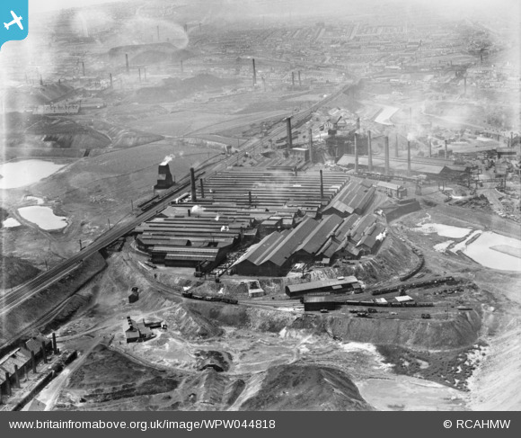
WPW044818 WALES (1934). View of the British Mannesmann Tube Co., Landore, Swansea, oblique aerial view. 5"x4" black and white glass plate negative.
© Copyright OpenStreetMap contributors and licensed by the OpenStreetMap Foundation. 2024. Cartography is licensed as CC BY-SA.
Nearby Images (6)
WPW044815

WPW044816

WPW044817

WPW044818

WPW044819

WPW044820

Details
| Title | [WPW044818] View of the British Mannesmann Tube Co., Landore, Swansea, oblique aerial view. 5"x4" black and white glass plate negative. |
| Reference | WPW044818 |
| Date | 1934 |
| Link | Coflein Archive Item 6369815 |
| Place name | |
| Parish | |
| District | |
| Country | WALES |
| Easting / Northing | 266790, 196070 |
| Longitude / Latitude | -3.9255749743107, 51.64715875184 |
| National Grid Reference | SS668961 |
Pins
 The Mile End G.F. |
Thursday 4th of August 2022 12:37:58 PM | |
Harvey |
Thursday 19th of March 2015 07:15:30 PM | |
 Class31 |
Wednesday 16th of January 2013 07:38:23 PM | |
Class31 |
Wednesday 16th of January 2013 07:29:59 PM | |
Class31 |
Wednesday 16th of January 2013 07:25:42 PM | |
Class31 |
Friday 11th of January 2013 08:28:18 PM | |
Class31 |
Friday 11th of January 2013 08:25:51 PM | |
NR |
Tuesday 24th of July 2012 11:24:40 PM | |
Mark719 |
Tuesday 26th of June 2012 10:53:49 PM |
User Comment Contributions
Baldwins Landore Steelworks, previously the Landore Siemens-Steelworks, directly behind at the lower level. |
NR |
Tuesday 24th of July 2012 11:20:07 PM |


