
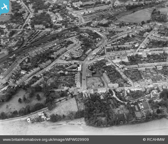
WPW029909 WALES (1929). General view of Abergavenny, oblique aerial view. 5"x4" black and white glass plate negative.
© Copyright OpenStreetMap contributors and licensed by the OpenStreetMap Foundation. 2024. Cartography is licensed as CC BY-SA.
Nearby Images (30)
WAW000674

WAW000675

WAW000676

WAW000677

WAW000678

WAW000679

WAW000680

WAW000681

WAW026200

WAW026201

WAW026202

WAW026203

WAW026204

WAW026205

WPW029891

WPW029892

WPW029893

WPW029897

WPW029898

WPW029899

WPW029900

WPW029901

WPW029909

WPW029950

WPW029976

WPW039965

WPW039966

WPW039967

WPW039968

WPW039969

Details
| Title | [WPW029909] General view of Abergavenny, oblique aerial view. 5"x4" black and white glass plate negative. |
| Reference | WPW029909 |
| Date | 1929 |
| Link | Coflein Archive Item 6370709 |
| Place name | |
| Parish | |
| District | |
| Country | WALES |
| Easting / Northing | 329833, 214333 |
| Longitude / Latitude | -3.0181841706239, 51.822762430277 |
| National Grid Reference | SO298143 |
Pins
 Beccy |
Friday 23rd of September 2016 04:29:14 PM | |
Beccy |
Wednesday 21st of September 2016 02:28:58 PM | |
Beccy |
Wednesday 21st of September 2016 02:26:33 PM | |
Stewart Lawrie |
Wednesday 8th of June 2016 03:06:27 PM | |
Stewart Lawrie |
Wednesday 8th of June 2016 03:02:39 PM | |
 Class31 |
Wednesday 4th of July 2012 08:04:58 AM | |
Class31 |
Wednesday 4th of July 2012 08:04:36 AM | |
Class31 |
Wednesday 4th of July 2012 08:03:35 AM | |
Class31 |
Wednesday 4th of July 2012 08:02:27 AM | |
Class31 |
Wednesday 4th of July 2012 08:00:32 AM | |
Class31 |
Wednesday 4th of July 2012 08:00:10 AM | |
Class31 |
Wednesday 4th of July 2012 07:59:17 AM | |
Class31 |
Wednesday 4th of July 2012 07:58:49 AM | |
Class31 |
Wednesday 4th of July 2012 07:58:05 AM |
User Comment Contributions
Dear all, thank you for your comments, following your spot on local knowledge we have now verified the location and changed the caption to the correct Abergavenny. Natasha Scullion Britain from Above Activity Officer |
Natasha Scullion |
Friday 31st of August 2012 04:56:53 PM |
Definitely not Monmouth. Street names/patterns and railway sidings all very different |
southwye |
Thursday 16th of August 2012 03:27:10 PM |
 This is a shot of Abergavenny Brecon Road incorrectly identified as Monmouth. |
Class31 |
Wednesday 4th of July 2012 08:12:57 AM |
This is an image of Abergavenny and not Monmouth. |
Class31 |
Wednesday 4th of July 2012 08:11:19 AM |
This is definitely Abergavenny - the railway bridge in the top middle is spanning Chapel Rd and Brecon Rd, plus goods sidings opposite where the Cantref Inn is now. |
Giles |
Thursday 28th of June 2012 05:47:02 PM |
I agree. I'm not convinced that this is Monmouth! The street layout doesn't look correct and there appears to be a railway bridge (top centre) - the two lines that ran into Monmouth had stations on the outskirts of the town. |
David |
Thursday 28th of June 2012 02:00:04 PM |
Is this Monmouth - does not look right to me? It looks more like Abergavenny with whats now Linda Vista Gardens and Castle Meadows in the forefront? |
Matt |
Tuesday 26th of June 2012 07:06:03 PM |


