
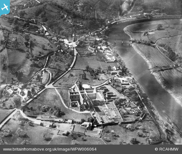
WPW006064 WALES (1921). View of Chapel Hill showing Tintern Abbey and railway viaduct. Oblique aerial photograph, 5"x4" BW glass plate.
© Copyright OpenStreetMap contributors and licensed by the OpenStreetMap Foundation. 2024. Cartography is licensed as CC BY-SA.
Nearby Images (17)
WAW006540

WAW006541

WAW006542

WAW006543

WAW006544

WAW006545

WAW007090

WAW007091

WAW007092

WAW007093

WAW007094

WAW007095

WAW007096

WAW007097

WAW007098

WAW017495

WPW006064

Details
| Title | [WPW006064] View of Chapel Hill showing Tintern Abbey and railway viaduct. Oblique aerial photograph, 5"x4" BW glass plate. |
| Reference | WPW006064 |
| Date | 1921 |
| Link | Coflein Archive Item 6422475 |
| Place name | |
| Parish | |
| District | |
| Country | WALES |
| Easting / Northing | 353310, 199990 |
| Longitude / Latitude | -2.6756170098079, 51.696253341799 |
| National Grid Reference | ST5331000 |
Pins
Be the first to add a comment to this image!
User Comment Contributions
 Tintern Abbey, 30/05/2016 |
 Class31 |
Saturday 4th of June 2016 09:28:39 AM |


