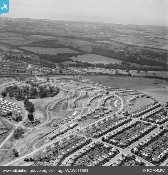
WAW031663 WALES (1950). View of Gaer housing estate showing newly built houses in 1950
© Copyright OpenStreetMap contributors and licensed by the OpenStreetMap Foundation. 2024. Cartography is licensed as CC BY-SA.
Nearby Images (19)
Details
| Title | [WAW031663] View of Gaer housing estate showing newly built houses in 1950 |
| Reference | WAW031663 |
| Date | 1950 |
| Link | Coflein Archive Item 6414338 |
| Place name | |
| Parish | |
| District | |
| Country | WALES |
| Easting / Northing | 329320, 186730 |
| Longitude / Latitude | -3.0200313338699, 51.574525589222 |
| National Grid Reference | ST293867 |
Pins
Be the first to add a comment to this image!


![[WAW011882] View of Newport showing Gaer Housing estates](http://britainfromabove.org.uk/sites/all/libraries/aerofilms-images/public/100x100/WAW/011/WAW011882.jpg)
![[WAW031651] View of Gaer housing estate showing newly built houses in 1950](http://britainfromabove.org.uk/sites/all/libraries/aerofilms-images/public/100x100/WAW/031/WAW031651.jpg)
![[WAW031652] View of Gaer housing estate showing newly built houses in 1950](http://britainfromabove.org.uk/sites/all/libraries/aerofilms-images/public/100x100/WAW/031/WAW031652.jpg)
![[WAW031653] View of Gaer housing estate showing newly built houses in 1950](http://britainfromabove.org.uk/sites/all/libraries/aerofilms-images/public/100x100/WAW/031/WAW031653.jpg)
![[WAW031654] View of Gaer housing estate showing newly built houses in 1950](http://britainfromabove.org.uk/sites/all/libraries/aerofilms-images/public/100x100/WAW/031/WAW031654.jpg)
![[WAW031655] View of Gaer housing estate showing newly built houses in 1950](http://britainfromabove.org.uk/sites/all/libraries/aerofilms-images/public/100x100/WAW/031/WAW031655.jpg)
![[WAW031656] View of Gaer housing estate showing newly built houses in 1950](http://britainfromabove.org.uk/sites/all/libraries/aerofilms-images/public/100x100/WAW/031/WAW031656.jpg)
![[WAW031657] View of Gaer housing estate showing newly built houses in 1950](http://britainfromabove.org.uk/sites/all/libraries/aerofilms-images/public/100x100/WAW/031/WAW031657.jpg)
![[WAW031658] View of Gaer housing estate showing newly built houses in 1950](http://britainfromabove.org.uk/sites/all/libraries/aerofilms-images/public/100x100/WAW/031/WAW031658.jpg)
![[WAW031659] View of Gaer housing estate showing newly built houses in 1950](http://britainfromabove.org.uk/sites/all/libraries/aerofilms-images/public/100x100/WAW/031/WAW031659.jpg)
![[WAW031660] View of Gaer housing estate showing newly built houses in 1950](http://britainfromabove.org.uk/sites/all/libraries/aerofilms-images/public/100x100/WAW/031/WAW031660.jpg)
![[WAW031661] View of Gaer housing estate showing newly built houses in 1950](http://britainfromabove.org.uk/sites/all/libraries/aerofilms-images/public/100x100/WAW/031/WAW031661.jpg)
![[WAW031662] View of Gaer housing estate showing newly built houses in 1950](http://britainfromabove.org.uk/sites/all/libraries/aerofilms-images/public/100x100/WAW/031/WAW031662.jpg)
![[WAW031663] View of Gaer housing estate showing newly built houses in 1950](http://britainfromabove.org.uk/sites/all/libraries/aerofilms-images/public/100x100/WAW/031/WAW031663.jpg)
![[WAW031664] View of Gaer housing estate showing newly built houses in 1950](http://britainfromabove.org.uk/sites/all/libraries/aerofilms-images/public/100x100/WAW/031/WAW031664.jpg)
![[WAW031665] View of Gaer housing estate showing newly built houses in 1950](http://britainfromabove.org.uk/sites/all/libraries/aerofilms-images/public/100x100/WAW/031/WAW031665.jpg)
![[WAW031666] View of Gaer housing estate showing newly built houses in 1950](http://britainfromabove.org.uk/sites/all/libraries/aerofilms-images/public/100x100/WAW/031/WAW031666.jpg)
![[WAW031667] View of Gaer housing estate showing newly built houses in 1950](http://britainfromabove.org.uk/sites/all/libraries/aerofilms-images/public/100x100/WAW/031/WAW031667.jpg)
![[WAW031668] View of Gaer housing estate showing newly built houses in 1950](http://britainfromabove.org.uk/sites/all/libraries/aerofilms-images/public/100x100/WAW/031/WAW031668.jpg)


