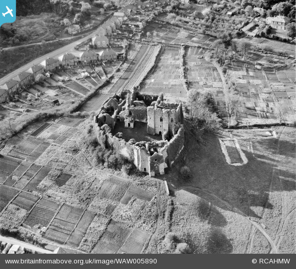
WAW005890 WALES (1947). View of Oystermouth Castle, Mumbles
© Copyright OpenStreetMap contributors and licensed by the OpenStreetMap Foundation. 2024. Cartography is licensed as CC BY-SA.
Nearby Images (19)
Details
| Title | [WAW005890] View of Oystermouth Castle, Mumbles |
| Reference | WAW005890 |
| Date | 15-May-1947 |
| Link | Coflein Archive Item 6413364 |
| Place name | |
| Parish | |
| District | |
| Country | WALES |
| Easting / Northing | 261320, 188360 |
| Longitude / Latitude | -4.0015429202709, 51.576547560667 |
| National Grid Reference | SS613884 |
Pins
Be the first to add a comment to this image!


![[WAW005887] View of Oystermouth Castle, Mumbles](http://britainfromabove.org.uk/sites/all/libraries/aerofilms-images/public/100x100/WAW/005/WAW005887.jpg)
![[WAW005888] View of Oystermouth Castle, Mumbles](http://britainfromabove.org.uk/sites/all/libraries/aerofilms-images/public/100x100/WAW/005/WAW005888.jpg)
![[WAW005889] View of Oystermouth Castle, Mumbles](http://britainfromabove.org.uk/sites/all/libraries/aerofilms-images/public/100x100/WAW/005/WAW005889.jpg)
![[WAW005890] View of Oystermouth Castle, Mumbles](http://britainfromabove.org.uk/sites/all/libraries/aerofilms-images/public/100x100/WAW/005/WAW005890.jpg)
![[WAW007661] View of Oystermouth castle showing surrounding allotment gardens. Oblique aerial photograph, 5½" cut roll film.](http://britainfromabove.org.uk/sites/all/libraries/aerofilms-images/public/100x100/WAW/007/WAW007661.jpg)
![[WAW007662] View of Oystermouth castle showing allotment gardens](http://britainfromabove.org.uk/sites/all/libraries/aerofilms-images/public/100x100/WAW/007/WAW007662.jpg)
![[WAW007663] View of Oystermouth castle showing allotment gardens](http://britainfromabove.org.uk/sites/all/libraries/aerofilms-images/public/100x100/WAW/007/WAW007663.jpg)
![[WAW007664] View of Oystermouth castle showing allotment gardens](http://britainfromabove.org.uk/sites/all/libraries/aerofilms-images/public/100x100/WAW/007/WAW007664.jpg)
![[WAW007666] View of Oystermouth castle showing allotment gardens](http://britainfromabove.org.uk/sites/all/libraries/aerofilms-images/public/100x100/WAW/007/WAW007666.jpg)
![[WAW007978] View of Oystermouth castle showing allotment gardens](http://britainfromabove.org.uk/sites/all/libraries/aerofilms-images/public/100x100/WAW/007/WAW007978.jpg)
![[WAW007979] View of Oystermouth castle showing allotment gardens](http://britainfromabove.org.uk/sites/all/libraries/aerofilms-images/public/100x100/WAW/007/WAW007979.jpg)
![[WAW007980] View of Oystermouth Castle showing allotments. Oblique aerial photograph, 5½" cut roll film.](http://britainfromabove.org.uk/sites/all/libraries/aerofilms-images/public/100x100/WAW/007/WAW007980.jpg)
![[WAW007981] View of Oystermouth castle showing allotment gardens](http://britainfromabove.org.uk/sites/all/libraries/aerofilms-images/public/100x100/WAW/007/WAW007981.jpg)
![[WAW007982] View of Oystermouth Castle showing allotments. Oblique aerial photograph, 5½" cut roll film.](http://britainfromabove.org.uk/sites/all/libraries/aerofilms-images/public/100x100/WAW/007/WAW007982.jpg)
![[WAW007983] View of Oystermouth castle showing allotment gardens](http://britainfromabove.org.uk/sites/all/libraries/aerofilms-images/public/100x100/WAW/007/WAW007983.jpg)
![[WAW023850] View of Oystermouth castle showing Coltshill quarries](http://britainfromabove.org.uk/sites/all/libraries/aerofilms-images/public/100x100/WAW/023/WAW023850.jpg)
![[WAW023851] View of Oystermouth castle showing Coltshill quarries](http://britainfromabove.org.uk/sites/all/libraries/aerofilms-images/public/100x100/WAW/023/WAW023851.jpg)
![[WAW023852] View of Oystermouth castle and village](http://britainfromabove.org.uk/sites/all/libraries/aerofilms-images/public/100x100/WAW/023/WAW023852.jpg)
![[WAW023853] View of Oystermouth castle and village](http://britainfromabove.org.uk/sites/all/libraries/aerofilms-images/public/100x100/WAW/023/WAW023853.jpg)


