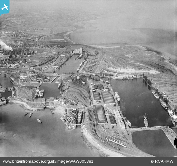
WAW005381 WALES (1947). View of Cardiff Docks
© Copyright OpenStreetMap contributors and licensed by the OpenStreetMap Foundation. 2024. Cartography is licensed as CC BY-SA.
Nearby Images (29)
Details
| Title | [WAW005381] View of Cardiff Docks |
| Reference | WAW005381 |
| Date | 13-May-1947 |
| Link | Coflein Archive Item 6413279 |
| Place name | |
| Parish | |
| District | |
| Country | WALES |
| Easting / Northing | 319000, 174000 |
| Longitude / Latitude | -3.1660087748727, 51.458686385872 |
| National Grid Reference | ST190740 |
Pins
 Richard |
Sunday 12th of June 2022 03:35:38 AM | |
 redmist |
Tuesday 24th of November 2020 03:48:34 PM | |
 redmist |
Tuesday 24th of November 2020 03:47:42 PM | |
 redmist |
Tuesday 24th of November 2020 03:47:21 PM | |
 redmist |
Tuesday 24th of November 2020 01:08:43 PM | |
 redmist |
Tuesday 24th of November 2020 01:07:13 PM | |
 redmist |
Tuesday 24th of November 2020 01:06:18 PM |


![[WAW005380] View of Cardiff Docks](http://britainfromabove.org.uk/sites/all/libraries/aerofilms-images/public/100x100/WAW/005/WAW005380.jpg)
![[WAW005381] View of Cardiff Docks](http://britainfromabove.org.uk/sites/all/libraries/aerofilms-images/public/100x100/WAW/005/WAW005381.jpg)
![[WAW005382] View of Cardiff Docks](http://britainfromabove.org.uk/sites/all/libraries/aerofilms-images/public/100x100/WAW/005/WAW005382.jpg)
![[WAW007810] View of Cardiff docks from the south with Queen Alexandra dock in the foreground. Oblique aerial photograph, 5½" cut roll film.](http://britainfromabove.org.uk/sites/all/libraries/aerofilms-images/public/100x100/WAW/007/WAW007810.jpg)
![[WAW007811] View of Cardiff docks from the south with Queen Alexandra dock in the foreground. Oblique aerial photograph, 5½" cut roll film.](http://britainfromabove.org.uk/sites/all/libraries/aerofilms-images/public/100x100/WAW/007/WAW007811.jpg)
![[WAW007813] View of Cardiff docks from the south with Queen Alexandra dock in the foreground. Oblique aerial photograph, 5½" cut roll film.](http://britainfromabove.org.uk/sites/all/libraries/aerofilms-images/public/100x100/WAW/007/WAW007813.jpg)
![[WAW007815] Distant view of Cardiff docks. Oblique aerial photograph, 5½" cut roll film.](http://britainfromabove.org.uk/sites/all/libraries/aerofilms-images/public/100x100/WAW/007/WAW007815.jpg)
![[WAW007818] View of Cardiff docks from the south showing East and West Butes docks. Oblique aerial photograph, 5½" cut roll film.](http://britainfromabove.org.uk/sites/all/libraries/aerofilms-images/public/100x100/WAW/007/WAW007818.jpg)
![[WAW007823] View of Cardiff docks from the east with Roath dock in the foreground. Oblique aerial photograph, 5½" cut roll film.](http://britainfromabove.org.uk/sites/all/libraries/aerofilms-images/public/100x100/WAW/007/WAW007823.jpg)
![[WAW007825] View of Cardiff docks from the west. Oblique aerial photograph, 5½" cut roll film.](http://britainfromabove.org.uk/sites/all/libraries/aerofilms-images/public/100x100/WAW/007/WAW007825.jpg)
![[WAW007827] View of Cardiff docks from the south with Queen Alexandra dock in the foreground. Oblique aerial photograph, 5½" cut roll film.](http://britainfromabove.org.uk/sites/all/libraries/aerofilms-images/public/100x100/WAW/007/WAW007827.jpg)
![[WAW033669] General view of Cardiff docks](http://britainfromabove.org.uk/sites/all/libraries/aerofilms-images/public/100x100/WAW/033/WAW033669.jpg)
![[WAW033672] General view of Cardiff docks](http://britainfromabove.org.uk/sites/all/libraries/aerofilms-images/public/100x100/WAW/033/WAW033672.jpg)
![[WAW033676] General view of Cardiff docks](http://britainfromabove.org.uk/sites/all/libraries/aerofilms-images/public/100x100/WAW/033/WAW033676.jpg)
![[WPW006077] General view of Cardiff docks, oblique aerial view. 5"x4" black and white glass plate negative.](http://britainfromabove.org.uk/sites/all/libraries/aerofilms-images/public/100x100/WPW/006/WPW006077.jpg)
![[WPW006078] View of Queens Dock, Cardiff showing railway sidings, oblique aerial view. 5"x4" black and white glass plate negative.](http://britainfromabove.org.uk/sites/all/libraries/aerofilms-images/public/100x100/WPW/006/WPW006078.jpg)
![[WPW006079] General view of Cardiff docks, oblique aerial view. 5"x4" black and white glass plate negative.](http://britainfromabove.org.uk/sites/all/libraries/aerofilms-images/public/100x100/WPW/006/WPW006079.jpg)
![[WPW006080] General view of Cardiff docks, oblique aerial view. 5"x4" black and white glass plate negative.](http://britainfromabove.org.uk/sites/all/libraries/aerofilms-images/public/100x100/WPW/006/WPW006080.jpg)
![[WPW029420] View of Cardiff showing docks and Butetown, oblique aerial view. 5"x4" black and white glass plate negative.](http://britainfromabove.org.uk/sites/all/libraries/aerofilms-images/public/100x100/WPW/029/WPW029420.jpg)
![[WPW029431] View of Cardiff showing Bute East Dock, oblique aerial view. 5"x4" black and white glass plate negative.](http://britainfromabove.org.uk/sites/all/libraries/aerofilms-images/public/100x100/WPW/029/WPW029431.jpg)
![[WPW029432] View of Cardiff showing Bute East Dock and East Moors Works, oblique aerial view. 5"x4" black and white glass plate negative.](http://britainfromabove.org.uk/sites/all/libraries/aerofilms-images/public/100x100/WPW/029/WPW029432.jpg)
![[WPW041270] View of Cardiff Docks, oblique aerial view. 5"x4" black and white glass plate negative.](http://britainfromabove.org.uk/sites/all/libraries/aerofilms-images/public/100x100/WPW/041/WPW041270.jpg)
![[WPW041271] View of Cardiff Docks, oblique aerial view. 5"x4" black and white glass plate negative.](http://britainfromabove.org.uk/sites/all/libraries/aerofilms-images/public/100x100/WPW/041/WPW041271.jpg)
![[WPW041272] View of Cardiff Docks, oblique aerial view. 5"x4" black and white glass plate negative.](http://britainfromabove.org.uk/sites/all/libraries/aerofilms-images/public/100x100/WPW/041/WPW041272.jpg)
![[WPW041273] View of Cardiff Docks, oblique aerial view. 5"x4" black and white glass plate negative.](http://britainfromabove.org.uk/sites/all/libraries/aerofilms-images/public/100x100/WPW/041/WPW041273.jpg)
![[WPW052630] Distant view of Cardiff docks, oblique aerial view. 5"x4" black and white glass plate negative.](http://britainfromabove.org.uk/sites/all/libraries/aerofilms-images/public/100x100/WPW/052/WPW052630.jpg)
![[WPW054860] View of cardiff docks, oblique aerial view. 5"x4" black and white glass plate negative.](http://britainfromabove.org.uk/sites/all/libraries/aerofilms-images/public/100x100/WPW/054/WPW054860.jpg)
![[WPW054866] General view of cardiff docks, oblique aerial view. 5"x4" black and white glass plate negative.](http://britainfromabove.org.uk/sites/all/libraries/aerofilms-images/public/100x100/WPW/054/WPW054866.jpg)
![[WPW054867] General view of cardiff docks, oblique aerial view. 5"x4" black and white glass plate negative.](http://britainfromabove.org.uk/sites/all/libraries/aerofilms-images/public/100x100/WPW/054/WPW054867.jpg)


