
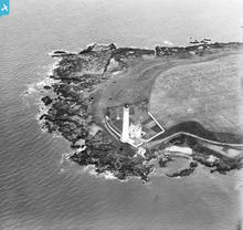
SPW033636 SCOTLAND (1930). Scurdie Ness Lighthouse, Montrose. An oblique aerial photograph taken facing south.

© Copyright OpenStreetMap contributors and licensed by the OpenStreetMap Foundation. 2024. Cartography is licensed as CC BY-SA.
Nearby Images (2)
SPW033635

SPW033636

Details
| Title | [SPW033636] Scurdie Ness Lighthouse, Montrose. An oblique aerial photograph taken facing south. |
| Reference | SPW033636 |
| Date | 1930 |
| Link | Canmore Collection item 1256987 |
| Place name | |
| Parish | CRAIG |
| District | ANGUS |
| Country | SCOTLAND |
| Easting / Northing | 373322, 756758 |
| Longitude / Latitude | -2.4357257771147, 56.701902780347 |
| National Grid Reference | NO733568 |
Pins
Be the first to add a comment to this image!
User Comment Contributions
The nighttime photograph of Scurdie Ness is a fantastic picture can this be reproduced on a canvas |
 antiquedogsbody |
Tuesday 26th of June 2012 08:03:00 PM |
 Check out the Scurdie Ness Lighthouse at Montrose...The word Scurdie is a local word meaning volcanic rock based on the geology of the coastline there. |
 Gazgirl |
Saturday 5th of May 2012 02:43:37 PM |
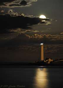 Here's a great pic of Scurdie Ness by moonlight. |
Gazgirl |
Saturday 5th of May 2012 02:43:37 PM |


