
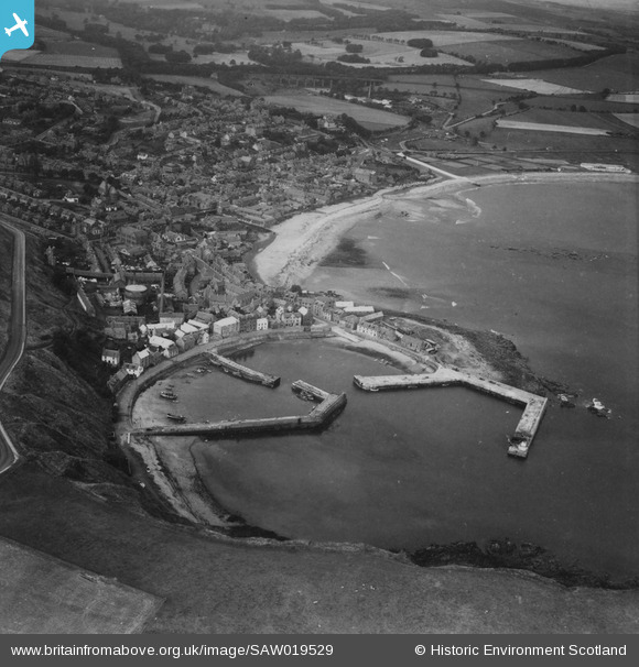
SAW019529 SCOTLAND (1948). Stonehaven, general view, showing Stonehaven Harbour and Glenury Viaduct. An oblique aerial photograph taken facing north. This image has been produced from a print.
© Copyright OpenStreetMap contributors and licensed by the OpenStreetMap Foundation. 2024. Cartography is licensed as CC BY-SA.
Nearby Images (2)
SAW019529

SAW019528

Details
| Title | [SAW019529] Stonehaven, general view, showing Stonehaven Harbour and Glenury Viaduct. An oblique aerial photograph taken facing north. This image has been produced from a print. |
| Reference | SAW019529 |
| Date | 1948 |
| Link | Canmore Collection item 1314917 |
| Place name | |
| Parish | DUNNOTTAR |
| District | KINCARDINE AND DEESIDE |
| Country | SCOTLAND |
| Easting / Northing | 387725, 785536 |
| Longitude / Latitude | -2.2018736566312, 56.961058766196 |
| National Grid Reference | NO877855 |
Pins
 1st Stonehaven Cowie Airscouts |
Monday 6th of January 2014 11:48:15 AM | |
1st Stonehaven Cowie Airscouts |
Monday 6th of January 2014 11:47:41 AM | |
1st Stonehaven Cowie Airscouts |
Monday 6th of January 2014 11:46:55 AM | |
1st Stonehaven Cowie Airscouts |
Monday 6th of January 2014 11:46:04 AM | |
Brian Wilkinson |
Monday 6th of January 2014 11:37:18 AM | |
Brian Wilkinson |
Monday 6th of January 2014 11:36:47 AM | |
Brian Wilkinson |
Monday 6th of January 2014 11:34:27 AM |
User Comment Contributions
 The comments on this picture were collected from the local community by members of the 1st Stonehaven Cowie Airscouts at their Community Heritage Day on 24/11/13. |
Brian Wilkinson |
Monday 6th of January 2014 11:39:23 AM |
An oblique view of the harbour and town beyond. |
Brian Wilkinson |
Monday 25th of November 2013 02:51:06 PM |


