
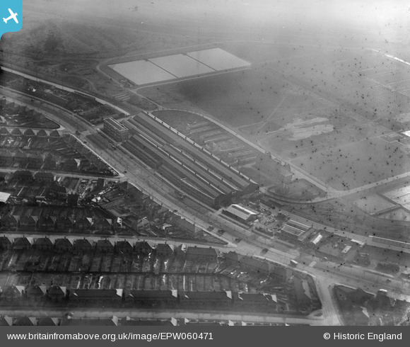
EPW060471 ENGLAND (1939). The Birmingham Electric Furnaces Ltd Works on Tyburn Road, Tyburn, 1939. This image has been produced from a damaged negative.
© Copyright OpenStreetMap contributors and licensed by the OpenStreetMap Foundation. 2024. Cartography is licensed as CC BY-SA.
Nearby Images (35)
EPW060471

EPW054223

EPW060470

EPW054224

EPW060537

EAW008640

EPW060533

EPW060536

EPW060532

EPW054228

EAW008635

EPW060535

EPW054227

EPW060534

EPW047151

EAW008638

EPW060531

EPW054225

EPW047155

EPW047156

EAW008633

EAW008631

EAW008637

EPW054226

EPW047150

EAW008636

EPW047152

EPW047153

EPW047154

EPW047149

EAW008634

EPW047157

EAW008639

EAW008632

EPW052832

Details
| Title | [EPW060471] The Birmingham Electric Furnaces Ltd Works on Tyburn Road, Tyburn, 1939. This image has been produced from a damaged negative. |
| Reference | EPW060471 |
| Date | 9-February-1939 |
| Link | |
| Place name | TYBURN |
| Parish | |
| District | |
| Country | ENGLAND |
| Easting / Northing | 410610, 290076 |
| Longitude / Latitude | -1.8436579722089, 52.50810836155 |
| National Grid Reference | SP106901 |
Pins
 stevebirch |
Wednesday 19th of February 2014 02:02:35 AM | |
stevebirch |
Wednesday 19th of February 2014 02:02:06 AM | |
stevebirch |
Wednesday 19th of February 2014 02:01:37 AM | |
stevebirch |
Wednesday 19th of February 2014 02:01:08 AM | |
stevebirch |
Wednesday 19th of February 2014 02:00:34 AM |


