
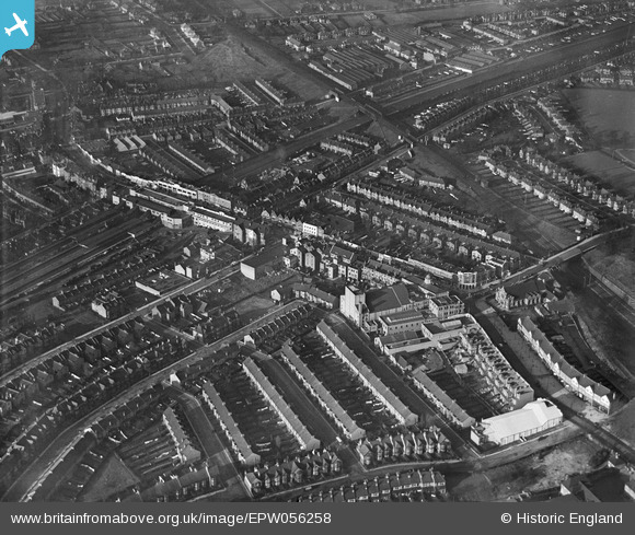
EPW056258 ENGLAND (1938). Wembley Central Station, Rosemead Avenue and environs, Wembley, 1938
© Copyright OpenStreetMap contributors and licensed by the OpenStreetMap Foundation. 2024. Cartography is licensed as CC BY-SA.
Nearby Images (5)
EPW056258

EPW056259

EPW056257

EPW056263

EPW007837

Details
| Title | [EPW056258] Wembley Central Station, Rosemead Avenue and environs, Wembley, 1938 |
| Reference | EPW056258 |
| Date | 17-January-1938 |
| Link | |
| Place name | WEMBLEY |
| Parish | |
| District | |
| Country | ENGLAND |
| Easting / Northing | 518321, 185170 |
| Longitude / Latitude | -0.29321642589332, 51.552516773691 |
| National Grid Reference | TQ183852 |
Pins

User Comment Contributions
 Wembley 1938 |
 classicforever |
Friday 21st of February 2014 05:16:51 AM |
Not to put too finer point on it but in 1938 the station was "Wembley for Sudbury" in LMS days and became "Central" after nationalization in 1948 under "British Rail." |
Wilmington |
Friday 21st of February 2014 05:14:04 AM |
beg pardon..."British Railways." |
Wilmington |
Friday 21st of February 2014 05:16:51 AM |


