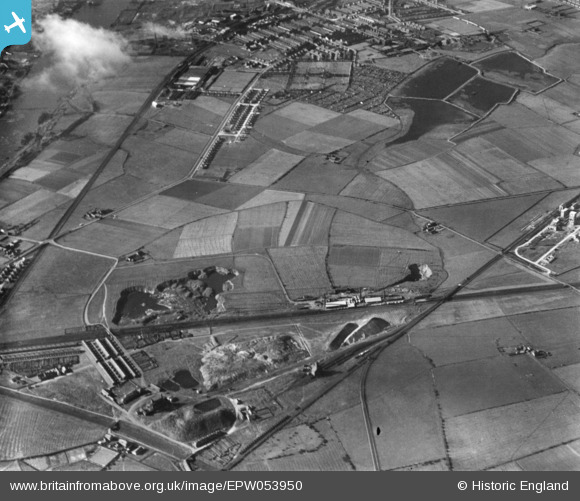
EPW053950 ENGLAND (1937). The Wardley Colliery, Victoria Road and Hebburn New Town, Hebburn, 1937. This image has been produced from a print.

© Copyright OpenStreetMap contributors and licensed by the OpenStreetMap Foundation. 2024. Cartography is licensed as CC BY-SA.

Details

Title [EPW053950] The Wardley Colliery, Victoria Road and Hebburn New Town, Hebburn, 1937. This image has been produced from a print.
Reference EPW053950
Date June-1937
Link
Place name HEBBURN
Parish
District
Country ENGLAND
Easting / Northing 430767, 562674
Longitude / Latitude -1.5194863705024, 54.957676853685
National Grid Reference NZ308627

Pins

Wardley Primary (infants) school. My father went there between 1933-1940

John Barker
Sunday 31st of December 2023 06:01:23 PM
Hartleyburn Avenue

N Dunn
Tuesday 11th of October 2016 03:05:01 PM

N Dunn
Tuesday 11th of October 2016 03:03:58 PM

N Dunn
Tuesday 11th of October 2016 03:02:59 PM
This was an old Quarry.

N Dunn
Tuesday 17th of March 2015 06:45:54 PM
Leslie's Sportsfield

N Dunn
Tuesday 17th of March 2015 06:43:39 PM
Tharsis Sulpher & Copper Works. This company had a mine in the Huelvo area of Spain inland from the Costa Del Sol in the mountain region.

N Dunn
Tuesday 17th of March 2015 06:42:08 PM
This is the 'Bushing Company' factory next door to the Reyrolle Works

N Dunn
Tuesday 17th of March 2015 06:39:32 PM
Victoria Rd west in Hebburn

N Dunn
Tuesday 17th of March 2015 06:38:22 PM
Redhouse Farm min Hebburn. Photo from my www,oldtyneside.co.uk website

N Dunn
Tuesday 17th of March 2015 06:36:52 PM
St Cuthbert's Vicarage built away from the smoke and noises of industry along the riverside of Hebburn. That vicarage is long gone and a new one was built next to the church, Photo from my www.oldtyneside.co.uk website

N Dunn
Tuesday 17th of March 2015 06:35:36 PM
This empty land soon became the home for Hebburn Technical College. Today in 2015 it is awaiting demolition as it hasn't been used for a number of years. Photos of it on my www.oldtyneside.co.uk website

N Dunn
Tuesday 17th of March 2015 06:28:35 PM
Wardley Lane leading from the Colliery to Bill Quay Bridge

N Dunn
Tuesday 17th of March 2015 06:25:46 PM
This was a covered reservoir on the corner of Victoria Rd West (Hebburn) and Mill Lane. In the early 1900s locals called Mill Lane 'the waterworks road' probably because of the reservoir

N Dunn
Tuesday 17th of March 2015 06:24:32 PM
Mill Farm which is at the side of Mill Lane

N Dunn
Tuesday 17th of March 2015 06:22:02 PM
Monkton Coke Works

N Dunn
Tuesday 17th of March 2015 06:21:14 PM
Jones's Brickyard close to their Quarries where they took the clay from for brick making

N Dunn
Tuesday 17th of March 2015 06:20:01 PM
Hebburn Cemetery

N Dunn
Thursday 6th of November 2014 01:23:27 PM
Wardley Lane leading to Bill Quay bridge

N Dunn
Thursday 30th of October 2014 05:00:04 PM
Second Street, Wardley Colliery

N Dunn
Thursday 30th of October 2014 04:59:00 PM
First Street, Wardley Colliery. All these houses are long gone.

N Dunn
Thursday 30th of October 2014 04:58:15 PM
Third St, Wardley Colliery

N Dunn
Thursday 30th of October 2014 04:56:45 PM
Hebburn Hall (Ellison Hall ). In 1937 it no longer was the Ellison families home as they'd gave it over to be an Infirmary. Photos of it and the area on my www.oldtyneside.co.uk website

N Dunn
Thursday 30th of October 2014 04:54:34 PM
Burn Heads Farm which is long gone.

N Dunn
Thursday 30th of October 2014 04:51:39 PM
Reyrolles & its sports field infront & then Victoria Rd west with the Cemetery across the road. I have photos of this area on my www.oldtyneside.co.uk website

N Dunn
Thursday 30th of October 2014 04:50:42 PM
Hebburn's Fever Hospital. My mothers little sister Margaret Rodgers died in this hospital 2 yrs before this aerial photo was taken. She was just 5 yrs old & in isolation so all the family could do was look through the window & see her fighting for life.

N Dunn
Thursday 30th of October 2014 04:48:38 PM
Thistley House Farm , Wardley. Why not check out my other website for Wardley, Bill Quay photos? www.gatesheadeast.co.uk

N Dunn
Thursday 30th of October 2014 04:39:54 PM
This was the Second Lake close to the Park. There used to be a Boathouse on the eastern shore that was once used by the Ellison family who owned Hebburn Hall. The park had been their private garden & the lakes their ponds. It was that landowning family that in the 1860s possibly 70s had earth embankments constructed to form the shape of the lakes as you see them on this photo. The burn that flowed over the area then filled them naturally. Before those lakes were constructed the area was farmland.

N Dunn
Thursday 30th of October 2014 04:37:19 PM
This was called the Island Lake as it had a small island in the middle where Swans & ducks could safely nest.

N Dunn
Thursday 30th of October 2014 04:29:50 PM
This Lake was known as the First Lake. It had a Pump house that stood on the top of the Bank at the eastern end & where water was drawn off & pumped for Industry use. In the 1950s the pump house was unused & empty of equipment apart from suction pipes leading into the lake.

N Dunn
Thursday 30th of October 2014 04:28:18 PM
This Hebburn lake was known locally as Sandy Bottom.

N Dunn
Thursday 30th of October 2014 04:23:15 PM
These were worked out Quarry's in Wardley. As young teenagers in the late 1950s the quarry was a playground for us boys.

N Dunn
Thursday 30th of October 2014 04:20:17 PM
Bill Quay School

N Dunn
Thursday 30th of October 2014 04:17:05 PM
Bluehouse Farm. just inside the Hebburn border

N Dunn
Thursday 30th of October 2014 04:16:29 PM
Wardley Colliery

N Dunn
Thursday 30th of October 2014 04:15:17 PM