
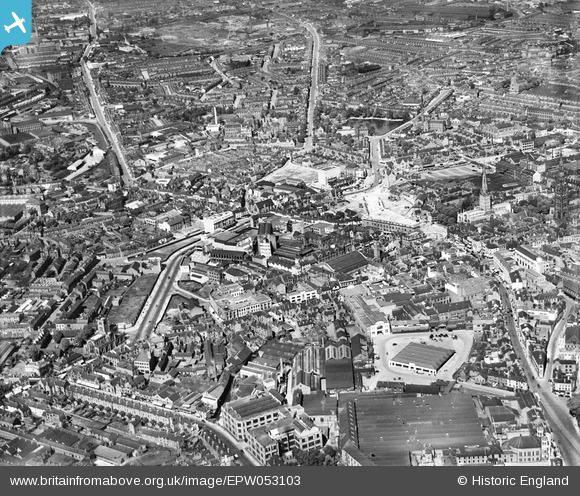
EPW053103 ENGLAND (1937). The city centre, Coventry, 1937
© Copyright OpenStreetMap contributors and licensed by the OpenStreetMap Foundation. 2024. Cartography is licensed as CC BY-SA.
Nearby Images (26)
EPW053103

EAW001828

EAW024995

EPW053109

EAW024996

EAW024991

EAW001832

EAW001834

EPW035762

EAW051846

EAW030280

EAW030282

EAW001835

EAW031598

EAW051852

EAW051845

EAW024984

EPW035764

EPW001190

EAW024985

EAW051849

EPW035763

EPW001202

EPW001199

EAW051848

EAW001829

Details
| Title | [EPW053103] The city centre, Coventry, 1937 |
| Reference | EPW053103 |
| Date | 18-May-1937 |
| Link | |
| Place name | COVENTRY |
| Parish | |
| District | |
| Country | ENGLAND |
| Easting / Northing | 433345, 279201 |
| Longitude / Latitude | -1.5097458621212, 52.409417696357 |
| National Grid Reference | SP333792 |
Pins
 NottmJas |
Wednesday 24th of January 2024 09:39:02 AM | |
Rocksolid |
Saturday 6th of January 2024 09:51:21 PM | |
Rocksolid |
Saturday 6th of January 2024 09:46:59 PM | |
RayG |
Thursday 12th of October 2023 07:51:51 PM | |
RayG |
Thursday 12th of October 2023 07:47:44 PM | |
RayG |
Thursday 12th of October 2023 07:45:37 PM | |
Malwight |
Friday 18th of March 2022 08:12:20 PM | |
Malwight |
Friday 18th of March 2022 08:10:55 PM | |
Malwight |
Friday 18th of March 2022 08:09:58 PM | |
John W |
Tuesday 18th of October 2016 03:32:58 PM | |
John W |
Tuesday 18th of October 2016 03:11:25 PM | |
rowles |
Monday 28th of December 2015 11:03:21 PM | |
rowles |
Monday 28th of December 2015 11:01:10 PM | |
Coventry kid |
Sunday 19th of January 2014 10:33:00 PM | |
Coventry kid |
Sunday 19th of January 2014 10:32:12 PM | |
Coventry kid |
Sunday 19th of January 2014 10:29:54 PM | |
Coventry kid |
Sunday 19th of January 2014 10:29:12 PM | |
Coventry kid |
Sunday 19th of January 2014 10:28:41 PM | |
Coventry kid |
Sunday 19th of January 2014 10:28:10 PM | |
Coventry kid |
Sunday 19th of January 2014 10:26:12 PM | |
Coventry kid |
Friday 1st of November 2013 10:19:11 PM | |
Coventry kid |
Friday 1st of November 2013 10:17:43 PM | |
Coventry kid |
Friday 1st of November 2013 10:16:31 PM | |
Coventry kid |
Friday 1st of November 2013 10:15:10 PM | |
Nat |
Tuesday 24th of September 2013 01:11:52 PM | |
Nat |
Tuesday 24th of September 2013 01:11:33 PM | |
Nat |
Tuesday 24th of September 2013 01:10:38 PM | |
Nat |
Tuesday 24th of September 2013 01:09:33 PM | |
Nat |
Tuesday 24th of September 2013 01:08:41 PM | |
Nat |
Tuesday 24th of September 2013 01:08:15 PM | |
Nat |
Tuesday 24th of September 2013 01:07:37 PM | |
Nat |
Tuesday 24th of September 2013 01:07:15 PM | |
JG |
Monday 12th of August 2013 09:58:39 PM | |
JG |
Monday 12th of August 2013 09:57:50 PM | |
JG |
Monday 12th of August 2013 09:56:00 PM |

User Comment Contributions
 From south, 18 May 1937 series. EPW053103 |
Nat |
Friday 27th of September 2013 04:46:23 PM |


