
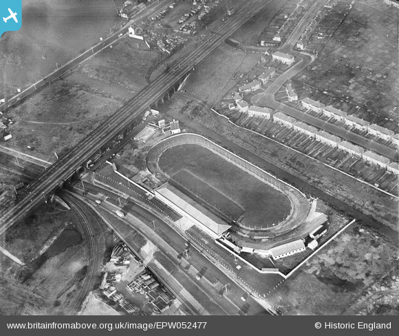
EPW052477 ENGLAND (1937). Hendon Greyhound Stadium, Hendon, 1937
© Copyright OpenStreetMap contributors and licensed by the OpenStreetMap Foundation. 2024. Cartography is licensed as CC BY-SA.
Nearby Images (6)
EPW052477

EPW053785

EPW053783

EPW006179

EPW038802

EAW048505

Details
| Title | [EPW052477] Hendon Greyhound Stadium, Hendon, 1937 |
| Reference | EPW052477 |
| Date | 13-February-1937 |
| Link | |
| Place name | HENDON |
| Parish | |
| District | |
| Country | ENGLAND |
| Easting / Northing | 522727, 187479 |
| Longitude / Latitude | -0.22888553485862, 51.572328923152 |
| National Grid Reference | TQ227875 |
Pins
 Class31 |
Saturday 22nd of March 2014 04:40:44 PM | |
Class31 |
Saturday 22nd of March 2014 04:40:02 PM | |
 SB83 |
Monday 24th of February 2014 03:44:19 PM | |
SB83 |
Monday 24th of February 2014 03:43:35 PM | |
Gladstone Hay |
Friday 6th of December 2013 10:48:22 PM | |
Gladstone Hay |
Friday 6th of December 2013 10:38:04 PM | |
Gladstone Hay |
Friday 6th of December 2013 10:35:21 PM | |
Gladstone Hay |
Friday 6th of December 2013 10:33:41 PM | |
BigglesH |
Thursday 17th of October 2013 01:23:05 AM | |
BigglesH |
Thursday 17th of October 2013 01:21:49 AM | |
BigglesH |
Thursday 17th of October 2013 01:17:05 AM |
User Comment Contributions
This photo was taken from the East. |
BigglesH |
Thursday 17th of October 2013 01:15:42 AM |


