
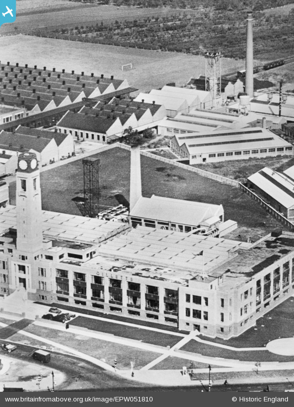
EPW051810 ENGLAND (1936). The Gillette Factory, Osterley, 1936. This image has been produced from a copy-negative.
© Copyright OpenStreetMap contributors and licensed by the OpenStreetMap Foundation. 2024. Cartography is licensed as CC BY-SA.
Nearby Images (21)
EPW051810

EPW059345

EPW040960

EPW034932

EPW034933

EPW040958

EPW032161

EPR000524
 Ltd Soldering Fluid Manufactory on the Great West Road, Spring Grove, 1935")
EAW050745

EPR000525
 Ltd Soldering Fluid Manufactory on the Great West Road, Spring Grove, 1935")
EPW050304

EPW031986

EPW034934

EPW060953

EPR000527

EAW050744

EPW035036

EAW050739

EPW035030

EPW022998

EAW050742

Details
| Title | [EPW051810] The Gillette Factory, Osterley, 1936. This image has been produced from a copy-negative. |
| Reference | EPW051810 |
| Date | September-1936 |
| Link | |
| Place name | OSTERLEY |
| Parish | |
| District | |
| Country | ENGLAND |
| Easting / Northing | 516240, 177520 |
| Longitude / Latitude | -0.32574478548458, 51.484186437794 |
| National Grid Reference | TQ162775 |
Pins
Be the first to add a comment to this image!
User Comment Contributions
 Gilette Building, Brentford, 22/07/2015 |
 Class31 |
Friday 24th of July 2015 06:37:09 AM |


