
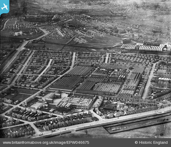
EPW046675 ENGLAND (1935). The Rolls-Royce Works and environs, Derby, from the south-east, 1935
© Copyright OpenStreetMap contributors and licensed by the OpenStreetMap Foundation. 2024. Cartography is licensed as CC BY-SA.
Nearby Images (13)
EPW046675

EAW013108

EPW046676

EAW013112

EPW046674

EPW046672

EPW046679

EAW013107

EAW013114

EAW013109

EPW046678

EPW046673

EAW013119

Details
| Title | [EPW046675] The Rolls-Royce Works and environs, Derby, from the south-east, 1935 |
| Reference | EPW046675 |
| Date | March-1935 |
| Link | |
| Place name | DERBY |
| Parish | |
| District | |
| Country | ENGLAND |
| Easting / Northing | 436540, 333496 |
| Longitude / Latitude | -1.4567567736485, 52.897344328578 |
| National Grid Reference | SK365335 |
Pins
 Peter Kazmierczak |
Saturday 5th of October 2013 09:35:44 PM | |
Peter Kazmierczak |
Saturday 5th of October 2013 09:34:45 PM | |
Peter Kazmierczak |
Saturday 5th of October 2013 09:32:48 PM | |
Peter Kazmierczak |
Saturday 5th of October 2013 09:31:55 PM | |
Peter Kazmierczak |
Saturday 5th of October 2013 09:30:56 PM | |
Peter Kazmierczak |
Saturday 5th of October 2013 09:30:03 PM | |
Peter Kazmierczak |
Saturday 5th of October 2013 09:28:48 PM | |
Peter Kazmierczak |
Saturday 5th of October 2013 09:28:12 PM | |
Peter Kazmierczak |
Saturday 5th of October 2013 09:27:19 PM | |
Peter Kazmierczak |
Saturday 5th of October 2013 09:26:00 PM |


