
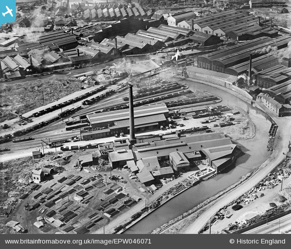
EPW046071 ENGLAND (1934). Rolling Mills and Goods Station at the Oldbury Canal Basin, Oldbury, 1934
© Copyright OpenStreetMap contributors and licensed by the OpenStreetMap Foundation. 2024. Cartography is licensed as CC BY-SA.
Nearby Images (29)
EPW046071

EAW021481

EAW021478

EPW046068

EAW021479

EAW021482

EPW046072

EPW046070

EAW021483

EAW021484

EPW046069

EAW021480

EAW021485

EPW046084

EPW046083

EPW046081

EPW046079

EPW046077

EPW048860

EPW046078

EPW046085

EPW048865A

EPW048865

EPW046082

EPW046048

EPW046042

EPW046044

EPW046047

EPW046080

Details
| Title | [EPW046071] Rolling Mills and Goods Station at the Oldbury Canal Basin, Oldbury, 1934 |
| Reference | EPW046071 |
| Date | September-1934 |
| Link | |
| Place name | OLDBURY |
| Parish | |
| District | |
| Country | ENGLAND |
| Easting / Northing | 398626, 289658 |
| Longitude / Latitude | -2.0202446798048, 52.504451671941 |
| National Grid Reference | SO986897 |
Pins
 Piper |
Friday 19th of July 2013 10:26:47 PM |
User Comment Contributions
 This photograph shows the industrial heart of the Black Country with the canal interchanging traffic with the railway. All now gone! |
Martin |
Monday 20th of May 2013 03:25:29 PM |
Great light and a real sense of thriving industry and business |
 Oliver Brookes |
Monday 20th of May 2013 03:25:29 PM |


