
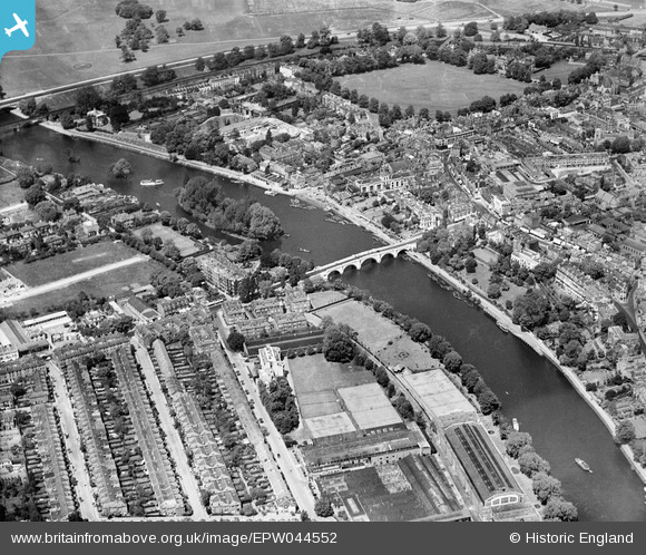
EPW044552 ENGLAND (1934). Richmond Bridge, Corporation Island and the town, Richmond, 1934
© Copyright OpenStreetMap contributors and licensed by the OpenStreetMap Foundation. 2024. Cartography is licensed as CC BY-SA.
Nearby Images (23)
EPW044552

EPW022837

EAW026799

EPW022844

EAW008242

EPW022838

EPW001695

EAW042759

EPW001693

EPW056173

EAW042758

EPW001694

EPW008871

EAW042757

EAW026798

EPW031987

EPW001696

EPW031992

EPW031989

EPW031991

EPW031988

EAW036494

EPW031990

Details
| Title | [EPW044552] Richmond Bridge, Corporation Island and the town, Richmond, 1934 |
| Reference | EPW044552 |
| Date | May-1934 |
| Link | |
| Place name | RICHMOND |
| Parish | |
| District | |
| Country | ENGLAND |
| Easting / Northing | 517682, 174506 |
| Longitude / Latitude | -0.30598864338945, 51.456796474059 |
| National Grid Reference | TQ177745 |
Pins
Be the first to add a comment to this image!
User Comment Contributions
 Richmond upon Thames |
 Alan McFaden |
Tuesday 25th of November 2014 05:08:39 PM |


