
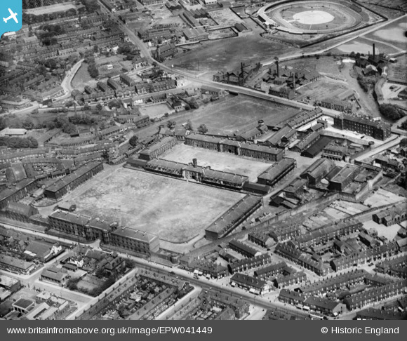
EPW041449 ENGLAND (1933). The Burdall's Buildings (formerly Hillsborough Barracks) and environs, Walkley, 1933
© Copyright OpenStreetMap contributors and licensed by the OpenStreetMap Foundation. 2024. Cartography is licensed as CC BY-SA.
Nearby Images (7)
EPW041449
 and environs, Walkley, 1933")
EPW041452
, Walkley, 1933")
EPW041454
, Walkley, 1933")
EPW041450
 and environs, Walkley, 1933")
EPW041453
 and environs, Walkley, 1933")
EPW041451
 and environs, Walkley, 1933")
EPW041626

Details
| Title | [EPW041449] The Burdall's Buildings (formerly Hillsborough Barracks) and environs, Walkley, 1933 |
| Reference | EPW041449 |
| Date | June-1933 |
| Link | |
| Place name | WALKLEY |
| Parish | |
| District | |
| Country | ENGLAND |
| Easting / Northing | 433660, 389559 |
| Longitude / Latitude | -1.4936782592509, 53.401518816007 |
| National Grid Reference | SK337896 |
Pins
 highsidedvehicles |
Tuesday 2nd of April 2019 06:28:29 PM | |
highsidedvehicles |
Tuesday 2nd of April 2019 06:27:52 PM | |
highsidedvehicles |
Tuesday 2nd of April 2019 06:26:15 PM | |
 Class31 |
Monday 20th of July 2015 02:00:28 PM | |
bayleaf |
Friday 14th of June 2013 07:39:04 PM |

User Comment Contributions
 Hillsborough Barracks, Sheffield, 14/07/2015 |
Class31 |
Tuesday 21st of July 2015 09:26:54 AM |
This image is the wrong way round - it needs to be flipped horizontally. The small tower in the bottom left hand corner of the parade ground should be on the right and the large black building in the top left corner of the site (married quarters - now demolished) should appear on the right. The covered stand at the Owlerton Stadium is on the left side of the track, as viewed from this side. |
Jak-Tyke |
Wednesday 26th of March 2014 01:27:35 PM |
Thanks for spotting this - I've arranged for the scan to be flipped and re-supplied to the website. Kind regards Laura Maddison (Britain from Above Cataloguer) |
 Laura Maddison |
Wednesday 26th of March 2014 01:27:35 PM |


