
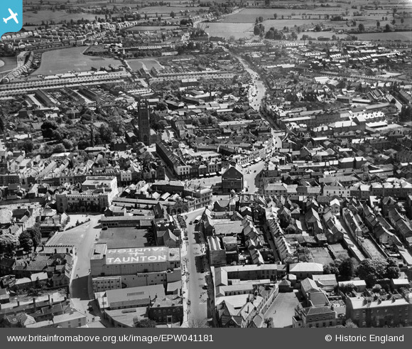
EPW041181 ENGLAND (1933). Fore Street and the town centre, Taunton, 1933
© Copyright OpenStreetMap contributors and licensed by the OpenStreetMap Foundation. 2024. Cartography is licensed as CC BY-SA.
Nearby Images (29)
EPW041181

EPW027899

EPW027893

EAW005347

EPW013541

EAW005346

EAW051944

EAW051943

EPW027885

EPW027886

EAW051947

EAW051941

EPW041093

EPW041184

EPW041094

EAW005343

EPW041183

EPW013539

EAW005339

EAW005342

EAW005341

EAW005337

EAW015036

EAW005340

EPW041182

EAW051945

EAW005338

EPW027892

EAW051946

Details
| Title | [EPW041181] Fore Street and the town centre, Taunton, 1933 |
| Reference | EPW041181 |
| Date | May-1933 |
| Link | |
| Place name | TAUNTON |
| Parish | |
| District | |
| Country | ENGLAND |
| Easting / Northing | 322756, 124528 |
| Longitude / Latitude | -3.1012790961226, 51.014397241516 |
| National Grid Reference | ST228245 |
Pins
 Class31 |
Saturday 16th of May 2015 11:14:52 PM | |
Class31 |
Saturday 16th of May 2015 12:51:13 PM | |
 John Wass |
Friday 5th of December 2014 07:22:45 PM | |
Applecounty |
Thursday 14th of August 2014 11:15:34 PM |

User Comment Contributions
 The Parish Church of Saint Mary Magdalen, Church Square, Taunton, 12/05/2015 |
Class31 |
Saturday 16th of May 2015 12:49:42 PM |


