
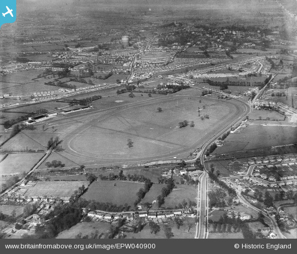
EPW040900 ENGLAND (1933). Northolt Park Race Course, Northolt, 1933
© Copyright OpenStreetMap contributors and licensed by the OpenStreetMap Foundation. 2024. Cartography is licensed as CC BY-SA.
Nearby Images (21)
EPW040900

EPW044554

EPW040902

EPW044273

EPR000013

EPW044270

EPW044271

EPW044950

EPR000621

EPW044944

EPW044268

EPW044266

EPW044949

EPW044269

EPW044272

EPW044946

EPW044945

EPW044947

EPR000014

EPW035054

EPW044267

Details
| Title | [EPW040900] Northolt Park Race Course, Northolt, 1933 |
| Reference | EPW040900 |
| Date | 27-March-1933 |
| Link | |
| Place name | NORTHOLT |
| Parish | |
| District | |
| Country | ENGLAND |
| Easting / Northing | 513332, 184929 |
| Longitude / Latitude | -0.36522833374008, 51.551374951231 |
| National Grid Reference | TQ133849 |
Pins
 GDT |
Monday 23rd of March 2020 10:19:48 PM | |
GDT |
Monday 23rd of March 2020 09:51:25 PM | |
The Laird |
Wednesday 25th of June 2014 06:23:12 PM | |
The Laird |
Wednesday 25th of June 2014 06:10:55 PM | |
Paul |
Thursday 13th of June 2013 08:52:05 PM |


