
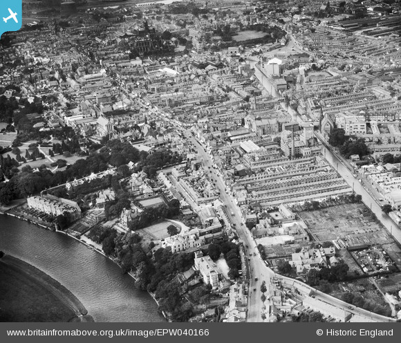
EPW040166 ENGLAND (1932). Boughton, Foregate Street and environs, Chester, 1932
© Copyright OpenStreetMap contributors and licensed by the OpenStreetMap Foundation. 2024. Cartography is licensed as CC BY-SA.
Nearby Images (4)
EPW040166

EPW036915

EPW003094

EPW040165

Details
| Title | [EPW040166] Boughton, Foregate Street and environs, Chester, 1932 |
| Reference | EPW040166 |
| Date | September-1932 |
| Link | |
| Place name | CHESTER |
| Parish | |
| District | |
| Country | ENGLAND |
| Easting / Northing | 341351, 366489 |
| Longitude / Latitude | -2.8779111657279, 53.191964099576 |
| National Grid Reference | SJ414665 |
Pins
 Kay |
Sunday 27th of January 2019 02:53:38 PM | |
Bunn72 |
Tuesday 9th of June 2015 07:53:38 PM | |
Bunn72 |
Tuesday 9th of June 2015 07:52:48 PM | |
Bunn72 |
Tuesday 9th of June 2015 07:51:58 PM | |
Bunn72 |
Tuesday 9th of June 2015 07:51:14 PM | |
Bunn72 |
Tuesday 9th of June 2015 07:50:38 PM | |
Bunn72 |
Tuesday 9th of June 2015 07:50:05 PM | |
Bunn72 |
Tuesday 9th of June 2015 07:49:41 PM | |
Bunn72 |
Tuesday 9th of June 2015 07:49:08 PM | |
Bunn72 |
Tuesday 9th of June 2015 07:48:47 PM | |
Bunn72 |
Tuesday 9th of June 2015 07:46:41 PM | |
Ange |
Saturday 24th of August 2013 11:19:13 PM | |
Ange |
Thursday 30th of May 2013 11:10:16 PM | |
Ange |
Thursday 30th of May 2013 11:09:46 PM |


