
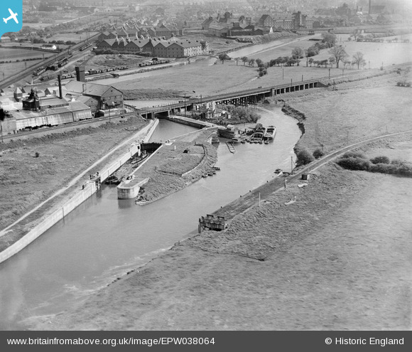
EPW038064 ENGLAND (1932). Nether Lock on the River Trent, Newark-on-Trent, 1932
© Copyright OpenStreetMap contributors and licensed by the OpenStreetMap Foundation. 2024. Cartography is licensed as CC BY-SA.
Nearby Images (14)
EPW038064

EPW038067

EPW038065

EPW038066

EAW036557
, Newark-on-Trent, 1951. This image has been produced from a print marked by Aerofilms Ltd for photo editing.")
EAW036564
, Newark-on-Trent, 1951. This image has been produced from a print marked by Aerofilms Ltd for photo editing.")
EAW036561
, Newark-on-Trent, 1951. This image has been produced from a print marked by Aerofilms Ltd for photo editing.")
EAW036558
, Newark-on-Trent, 1951. This image has been produced from a print marked by Aerofilms Ltd for photo editing.")
EAW036555
, Newark-on-Trent, 1951. This image has been produced from a print marked by Aerofilms Ltd for photo editing.")
EAW036559
, Newark-on-Trent, 1951. This image has been produced from a print marked by Aerofilms Ltd for photo editing.")
EAW036560
, Newark-on-Trent, 1951. This image has been produced from a print marked by Aerofilms Ltd for photo editing.")
EAW036562
, Newark-on-Trent, 1951. This image has been produced from a print marked by Aerofilms Ltd for photo editing.")
EAW036556
, Newark-on-Trent, 1951. This image has been produced from a print marked by Aerofilms Ltd for photo editing.")
EAW036563
, Newark-on-Trent, 1951. This image has been produced from a print marked by Aerofilms Ltd for photo editing.")
Details
| Title | [EPW038064] Nether Lock on the River Trent, Newark-on-Trent, 1932 |
| Reference | EPW038064 |
| Date | May-1932 |
| Link | |
| Place name | NEWARK-ON-TRENT |
| Parish | NEWARK |
| District | |
| Country | ENGLAND |
| Easting / Northing | 480023, 355425 |
| Longitude / Latitude | -0.80497316789908, 53.089733832902 |
| National Grid Reference | SK800554 |
Pins
 Deltic |
Wednesday 15th of April 2020 11:28:42 AM | |
Deltic |
Wednesday 15th of April 2020 11:27:39 AM | |
MB |
Friday 28th of December 2012 11:31:04 PM | |
MB |
Friday 28th of December 2012 11:30:33 PM | |
MB |
Friday 28th of December 2012 11:29:01 PM | |
MB |
Friday 28th of December 2012 11:27:42 PM | |
MB |
Friday 28th of December 2012 11:26:17 PM | |
MB |
Friday 28th of December 2012 11:25:31 PM |


