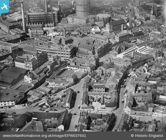
EPW037601 ENGLAND (1932). Oxford Street and environs, Kidderminster, 1932
© Copyright OpenStreetMap contributors and licensed by the OpenStreetMap Foundation. 2024. Cartography is licensed as CC BY-SA.
Nearby Images (25)
EPW037601

EPW033978

EPW037603

EPW037600

EPW037602

EPW059218

EPW059214

EPW059216

EPW059211

EPW059217

EPW059213

EPW059215

EPW059861

EPW037599

EPW059212

EPW033971

EPW033976

EPW034233

EPW001297

EPW033968

EPW033975

EPW037605

EPW001295

EPW033973

EPW033970

Details
| Title | [EPW037601] Oxford Street and environs, Kidderminster, 1932 |
| Reference | EPW037601 |
| Date | April-1932 |
| Link | |
| Place name | KIDDERMINSTER |
| Parish | |
| District | |
| Country | ENGLAND |
| Easting / Northing | 383198, 276525 |
| Longitude / Latitude | -2.2469003791838, 52.386115968483 |
| National Grid Reference | SO832765 |
Pins
 Class31 |
Sunday 16th of August 2015 09:15:49 AM | |
Class31 |
Sunday 16th of August 2015 09:11:01 AM | |
Class31 |
Sunday 16th of August 2015 09:06:25 AM | |
Class31 |
Sunday 16th of August 2015 09:04:25 AM | |
Class31 |
Sunday 16th of August 2015 08:55:12 AM | |
 |
Class31 |
Sunday 16th of August 2015 08:53:08 AM |