
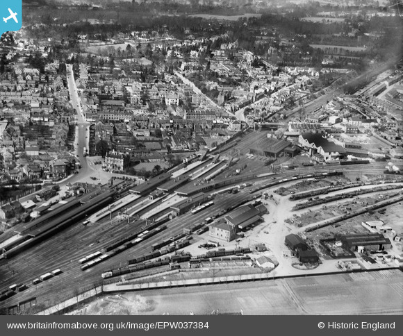
EPW037384 ENGLAND (1932). The Watford Junction and the town centre, Watford, 1932
© Copyright OpenStreetMap contributors and licensed by the OpenStreetMap Foundation. 2024. Cartography is licensed as CC BY-SA.
Nearby Images (18)
EPW037384

EAW038560

EAW048381

EAW048390

EAW048385

EAW048387

EAW048382

EAW048389

EAW048384

EAW048386

EPR000491

EPW060249

EPR000490

EPR000493

EAW038556
 premises and Watford Junction Railway Station, Watford, 1951. This image has been produced from a copy-negative.")
EAW048388

EAW048383

EPW021399

Details
| Title | [EPW037384] The Watford Junction and the town centre, Watford, 1932 |
| Reference | EPW037384 |
| Date | April-1932 |
| Link | |
| Place name | WATFORD |
| Parish | |
| District | |
| Country | ENGLAND |
| Easting / Northing | 510933, 197428 |
| Longitude / Latitude | -0.39586258912132, 51.66420313247 |
| National Grid Reference | TQ109974 |
Pins
 ordinarybloke |
Thursday 12th of November 2020 10:27:32 AM | |
Terry |
Saturday 10th of October 2020 09:32:12 AM | |
D869 |
Tuesday 18th of April 2017 12:41:35 PM | |
The Laird |
Saturday 11th of July 2015 06:47:06 PM | |
 Pdadme |
Sunday 18th of May 2014 12:25:54 PM | |
PRO |
Wednesday 27th of November 2013 01:43:29 AM | |
 John Swain |
Sunday 4th of August 2013 05:01:15 PM | |
John Swain |
Sunday 4th of August 2013 04:53:28 PM | |
John Swain |
Sunday 4th of August 2013 04:52:43 PM | |
John Swain |
Sunday 4th of August 2013 04:52:01 PM | |
John Swain |
Sunday 4th of August 2013 04:51:27 PM | |
John Swain |
Sunday 4th of August 2013 04:50:53 PM | |
The large-scale 1896 plan of Watford shows that three hotels were located within a few yards of the station, including the Malden and Clarendon. |
John Swain |
Sunday 4th of August 2013 05:26:50 PM |
John Swain |
Sunday 4th of August 2013 04:49:28 PM | |
John Swain |
Sunday 4th of August 2013 04:48:13 PM | |
John Swain |
Sunday 4th of August 2013 04:47:24 PM | |
John Swain |
Sunday 4th of August 2013 04:45:59 PM | |
John Swain |
Sunday 4th of August 2013 04:45:13 PM | |
John Swain |
Sunday 4th of August 2013 04:44:13 PM | |
John Swain |
Sunday 4th of August 2013 04:43:09 PM |

User Comment Contributions
 Any group relating to the growth and importance of Watford must surely include a picture of the Main Line station at Watford Junction and this is probably the clearest image available on the website. |
John Swain |
Sunday 4th of August 2013 05:36:40 PM |
 Watford Junction has undergone many changes and facelifts since 1932, most particularly with the clearance of the old station buildings in Woodford Road, to be replaced with car and bus parking areas and a huge office block. Modern track equipment is now in place, complementing the new rolling stock. |
John Swain |
Sunday 4th of August 2013 05:33:03 PM |
The railway helped in the development of the town in the second half of the 19th century. The original railway line between London and Birmingham was laid in 1837, and this was followed in 1858 and 1862 by the branch lines to St.Albans and Rickmansworth, respectively. The current Watford Junction Station was built in 1858 and through the remainder of the Victorian era, it became a major employer in the town, with an extensive goods yard, cattle pens, large engine shed and crane. By 1896, Watford was fast becoming a commuter town as links improved to London and it was no longer "a genteel market town". The town's reputation for fresh air and clean water attracted outside charities to set up institutions, including the London Orphan Asylum, built east of the station and west of the River Colne in 1870, for children from Clapton, north-east London, after a cholera outbreak. Residential development continued apace to the north and west of Watford Junction, and Callowland soon became North Watford by the 1930s. |
John Swain |
Sunday 4th of August 2013 05:18:17 PM |


