
EPW031546 ENGLAND (1930). Stag Lane Aerodrome and surroundings, Little Stanmore, from the south, 1930

© Copyright OpenStreetMap contributors and licensed by the OpenStreetMap Foundation. 2024. Cartography is licensed as CC BY-SA.
Nearby Images (48)
EPW031546

EPW030056

EPW015852

EPW015847

EPW015845

EPW025691

EPW015850

EPW015851

EPW015848

EPW015849

EPW032891

EPW030057

EPW030058

EPW025073

EPW031582

EPW034799

EPW022364

EPW046487

EPW022362

EPW034797

EPW047555

EPW034981

EPW034981
EPW031547

EPW047557

EPW032892

EPW025074

EPW018774

EPW047554

EPW018148

EPW047549

EPW018767

EPW013196

EPW013199

EPW032890

EPW034798

EPW047556

EPW047553

EPW022048

EPW018765

EPW034982

EPW034982
EPW047552

EPW032889

EPW009129

EPW047550

EPW046489

EPW035010

Details
| Title | [EPW031546] Stag Lane Aerodrome and surroundings, Little Stanmore, from the south, 1930 |
| Reference | EPW031546 |
| Date | February-1930 |
| Link | |
| Place name | LITTLE STANMORE |
| Parish | |
| District | |
| Country | ENGLAND |
| Easting / Northing | 519655, 190331 |
| Longitude / Latitude | -0.27222433107398, 51.598624005596 |
| National Grid Reference | TQ197903 |
Pins
 colsouth111 |
Wednesday 20th of August 2014 09:43:50 AM | |
colsouth111 |
Monday 18th of August 2014 07:39:54 PM | |
colsouth111 |
Monday 18th of August 2014 07:39:01 PM |
User Comment Contributions
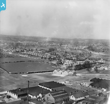 In the distance can be seen the rapid emergence of the Canada Park estate. |
colsouth111 |
Monday 18th of August 2014 07:41:52 PM |


