
EPW026378 ENGLAND (1929). Formby Golf Course and Club House, Formby, 1929

© Copyright OpenStreetMap contributors and licensed by the OpenStreetMap Foundation. 2024. Cartography is licensed as CC BY-SA.
Nearby Images (2)
EPW026378

EPW026377

Details
| Title | [EPW026378] Formby Golf Course and Club House, Formby, 1929 |
| Reference | EPW026378 |
| Date | April-1929 |
| Link | |
| Place name | FORMBY |
| Parish | FORMBY |
| District | |
| Country | ENGLAND |
| Easting / Northing | 328932, 408447 |
| Longitude / Latitude | -3.0732190663531, 53.567571392204 |
| National Grid Reference | SD289084 |
Pins

User Comment Contributions
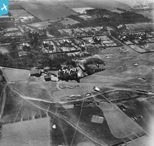 The original 18 hole course was redesigned by the famous Willie Park and a plan of the course (dated 1912) is displayed in the Hall Bar. James Braid changed the original 15th - 18th layout in 1922 to provide extra length. Minor changes were introduced by Messrs Hawtree & Taylor in 1933. In 1972 the high equinox spring tides undermined the sand hills and gale force winds regularly blew the loosened sand across the 8th green. New holes at 7, 8 & 9 were designed by Donald Steel of Frank Pennick & Partners, and a new 10th Tee playing to the existing 10th Green turned this into a short hole. These holes came into play in the early 80's and were used for the 1984 Amateur Championship. |
 royalfixit |
Thursday 7th of August 2014 05:16:45 PM |


